You are here: Home > Network List > TA - USArray Transportable Network (new EarthScope stations) Stations List
> Station R55A Marlinton, WV, USA > Earthquake Result Viewer
R55A Marlinton, WV, USA - Earthquake Result Viewer
| Earthquake location: |
Near Coast Of Northern Chile |
| Earthquake latitude/longitude: |
-19.8/-70.8 |
| Earthquake time(UTC): |
2014/06/19 (170) 19:54:05 GMT |
| Earthquake Depth: |
11 km |
| Earthquake Magnitude: |
5.7 MWB |
| Earthquake Catalog/Contributor: |
NEIC PDE/NEIC COMCAT |
|
| Network: |
TA USArray Transportable Network (new EarthScope stations) |
| Station: |
R55A Marlinton, WV, USA |
| Lat/Lon: |
38.28 N/80.12 W |
| Elevation: |
833 m |
|
| Distance: |
58.5 deg |
| Az: |
351.427 deg |
| Baz: |
169.729 deg |
| Ray Param: |
0.06282527 |
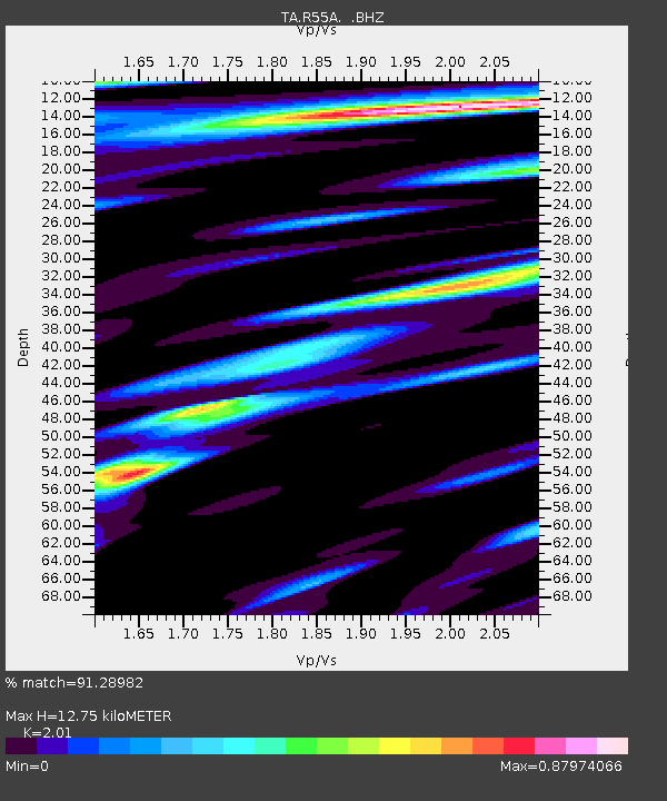
| Estimated Moho Depth: |
12.75 km |
| Estimated Crust Vp/Vs: |
2.01 |
| Assumed Crust Vp: |
6.207 km/s |
| Estimated Crust Vs: |
3.088 km/s |
| Estimated Crust Poisson's Ratio: |
0.34 |
|
| Radial Match: |
91.28982 % |
| Radial Bump: |
387 |
| Transverse Match: |
78.615814 % |
| Transverse Bump: |
400 |
| SOD ConfigId: |
739768 |
| Insert Time: |
2014-07-03 20:44:10.393 +0000 |
| GWidth: |
2.5 |
| Max Bumps: |
400 |
| Tol: |
0.001 |
|

Signal To Noise
| Channel | StoN | STA | LTA |
| TA:R55A: :BHZ:20140619T20:03:29.974993Z | 5.2527385 | 3.8271142E-7 | 7.285941E-8 |
| TA:R55A: :BHN:20140619T20:03:29.974993Z | 3.1331336 | 1.4268568E-7 | 4.5540887E-8 |
| TA:R55A: :BHE:20140619T20:03:29.974993Z | 1.0248486 | 4.9491998E-8 | 4.829201E-8 |
| Arrivals |
| Ps | 2.2 SECOND |
| PpPs | 5.9 SECOND |
| PsPs/PpSs | 8.1 SECOND |


