You are here: Home > Network List > TA - USArray Transportable Network (new EarthScope stations) Stations List
> Station G59A Clarenceville, QC, USA > Earthquake Result Viewer
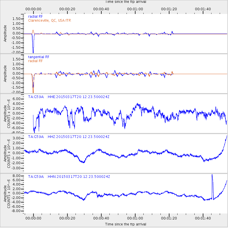
G59A Clarenceville, QC, USA - Earthquake Result Viewer
*The percent match for this event was below the threshold and hence no stack was calculated.
| Earthquake location: |
Kuril Islands |
| Earthquake latitude/longitude: |
43.5/146.2 |
| Earthquake time(UTC): |
2015/03/17 (076) 20:00:27 GMT |
| Earthquake Depth: |
80 km |
| Earthquake Magnitude: |
4.3 mb |
| Earthquake Catalog/Contributor: |
ISC/ISC |
|
| Network: |
TA USArray Transportable Network (new EarthScope stations) |
| Station: |
G59A Clarenceville, QC, USA |
| Lat/Lon: |
45.08 N/73.18 W |
| Elevation: |
36 m |
|
| Distance: |
85.1 deg |
| Az: |
26.819 deg |
| Baz: |
332.394 deg |
| Ray Param: |
$rayparam |
*The percent match for this event was below the threshold and hence was not used in the summary stack. |
|
| Radial Match: |
94.714005 % |
| Radial Bump: |
166 |
| Transverse Match: |
86.11225 % |
| Transverse Bump: |
293 |
| SOD ConfigId: |
7422571 |
| Insert Time: |
2019-04-17 19:27:50.554 +0000 |
| GWidth: |
2.5 |
| Max Bumps: |
400 |
| Tol: |
0.001 |
|
Signal To Noise
| Channel | StoN | STA | LTA |
| TA:G59A: :HHZ:20150317T20:12:23.500024Z | 0.6833765 | 6.259711E-7 | 9.1599736E-7 |
| TA:G59A: :HHN:20150317T20:12:23.500024Z | 0.632445 | 1.0501234E-6 | 1.6604185E-6 |
| TA:G59A: :HHE:20150317T20:12:23.500024Z | 0.79397523 | 2.039626E-6 | 2.5688785E-6 |
| Arrivals |
| Ps | |
| PpPs | |
| PsPs/PpSs | |


