You are here: Home > Network List > TA - USArray Transportable Network (new EarthScope stations) Stations List
> Station W41B Gary Mavity, Velonia, AR, USA > Earthquake Result Viewer
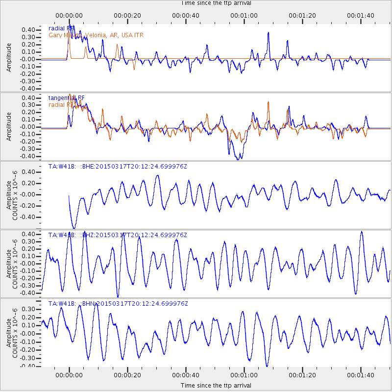
W41B Gary Mavity, Velonia, AR, USA - Earthquake Result Viewer
*The percent match for this event was below the threshold and hence no stack was calculated.
| Earthquake location: |
Kuril Islands |
| Earthquake latitude/longitude: |
43.5/146.2 |
| Earthquake time(UTC): |
2015/03/17 (076) 20:00:27 GMT |
| Earthquake Depth: |
80 km |
| Earthquake Magnitude: |
4.3 mb |
| Earthquake Catalog/Contributor: |
ISC/ISC |
|
| Network: |
TA USArray Transportable Network (new EarthScope stations) |
| Station: |
W41B Gary Mavity, Velonia, AR, USA |
| Lat/Lon: |
35.17 N/92.25 W |
| Elevation: |
95 m |
|
| Distance: |
85.3 deg |
| Az: |
44.462 deg |
| Baz: |
321.525 deg |
| Ray Param: |
$rayparam |
*The percent match for this event was below the threshold and hence was not used in the summary stack. |
|
| Radial Match: |
44.59125 % |
| Radial Bump: |
400 |
| Transverse Match: |
31.47956 % |
| Transverse Bump: |
400 |
| SOD ConfigId: |
7422571 |
| Insert Time: |
2019-04-17 19:28:32.793 +0000 |
| GWidth: |
2.5 |
| Max Bumps: |
400 |
| Tol: |
0.001 |
|
Signal To Noise
| Channel | StoN | STA | LTA |
| TA:W41B: :BHZ:20150317T20:12:24.699976Z | 1.7613245 | 2.5598294E-7 | 1.4533548E-7 |
| TA:W41B: :BHN:20150317T20:12:24.699976Z | 0.9793329 | 2.832561E-7 | 2.892337E-7 |
| TA:W41B: :BHE:20150317T20:12:24.699976Z | 1.1844279 | 2.238838E-7 | 1.8902273E-7 |
| Arrivals |
| Ps | |
| PpPs | |
| PsPs/PpSs | |


