You are here: Home > Network List > TA - USArray Transportable Network (new EarthScope stations) Stations List
> Station U59A Littleton, NC, USA > Earthquake Result Viewer
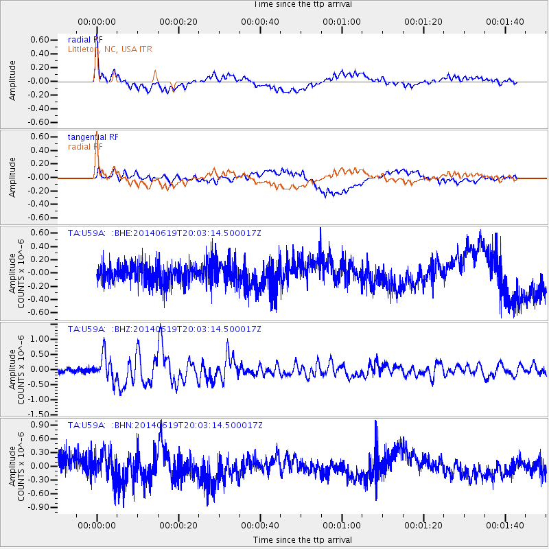
U59A Littleton, NC, USA - Earthquake Result Viewer
*The percent match for this event was below the threshold and hence no stack was calculated.
| Earthquake location: |
Near Coast Of Northern Chile |
| Earthquake latitude/longitude: |
-19.8/-70.8 |
| Earthquake time(UTC): |
2014/06/19 (170) 19:54:05 GMT |
| Earthquake Depth: |
11 km |
| Earthquake Magnitude: |
5.7 MWB |
| Earthquake Catalog/Contributor: |
NEIC PDE/NEIC COMCAT |
|
| Network: |
TA USArray Transportable Network (new EarthScope stations) |
| Station: |
U59A Littleton, NC, USA |
| Lat/Lon: |
36.35 N/77.79 W |
| Elevation: |
99 m |
|
| Distance: |
56.3 deg |
| Az: |
353.242 deg |
| Baz: |
172.113 deg |
| Ray Param: |
$rayparam |
*The percent match for this event was below the threshold and hence was not used in the summary stack. |
|
| Radial Match: |
53.28397 % |
| Radial Bump: |
400 |
| Transverse Match: |
48.415752 % |
| Transverse Bump: |
400 |
| SOD ConfigId: |
739768 |
| Insert Time: |
2014-07-03 20:46:19.898 +0000 |
| GWidth: |
2.5 |
| Max Bumps: |
400 |
| Tol: |
0.001 |
|
Signal To Noise
| Channel | StoN | STA | LTA |
| TA:U59A: :BHZ:20140619T20:03:14.500017Z | 5.742009 | 4.2090187E-7 | 7.330219E-8 |
| TA:U59A: :BHN:20140619T20:03:14.500017Z | 1.2307681 | 3.2343587E-7 | 2.627919E-7 |
| TA:U59A: :BHE:20140619T20:03:14.500017Z | 1.2383657 | 1.799726E-7 | 1.4533074E-7 |
| Arrivals |
| Ps | |
| PpPs | |
| PsPs/PpSs | |


