You are here: Home > Network List > TA - USArray Transportable Network (new EarthScope stations) Stations List
> Station V56A Mocksville, NC, USA > Earthquake Result Viewer
V56A Mocksville, NC, USA - Earthquake Result Viewer
| Earthquake location: |
Near Coast Of Northern Chile |
| Earthquake latitude/longitude: |
-19.8/-70.8 |
| Earthquake time(UTC): |
2014/06/19 (170) 19:54:05 GMT |
| Earthquake Depth: |
11 km |
| Earthquake Magnitude: |
5.7 MWB |
| Earthquake Catalog/Contributor: |
NEIC PDE/NEIC COMCAT |
|
| Network: |
TA USArray Transportable Network (new EarthScope stations) |
| Station: |
V56A Mocksville, NC, USA |
| Lat/Lon: |
35.81 N/80.50 W |
| Elevation: |
237 m |
|
| Distance: |
56.1 deg |
| Az: |
350.534 deg |
| Baz: |
169.02 deg |
| Ray Param: |
0.06436394 |
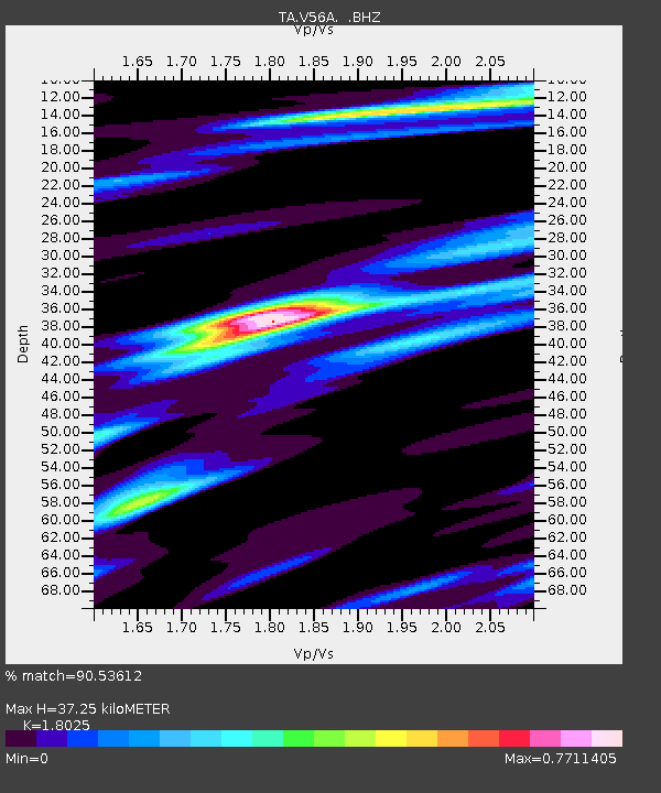
| Estimated Moho Depth: |
37.25 km |
| Estimated Crust Vp/Vs: |
1.80 |
| Assumed Crust Vp: |
6.419 km/s |
| Estimated Crust Vs: |
3.561 km/s |
| Estimated Crust Poisson's Ratio: |
0.28 |
|
| Radial Match: |
90.53612 % |
| Radial Bump: |
332 |
| Transverse Match: |
75.422615 % |
| Transverse Bump: |
400 |
| SOD ConfigId: |
739768 |
| Insert Time: |
2014-07-03 20:46:38.860 +0000 |
| GWidth: |
2.5 |
| Max Bumps: |
400 |
| Tol: |
0.001 |
|
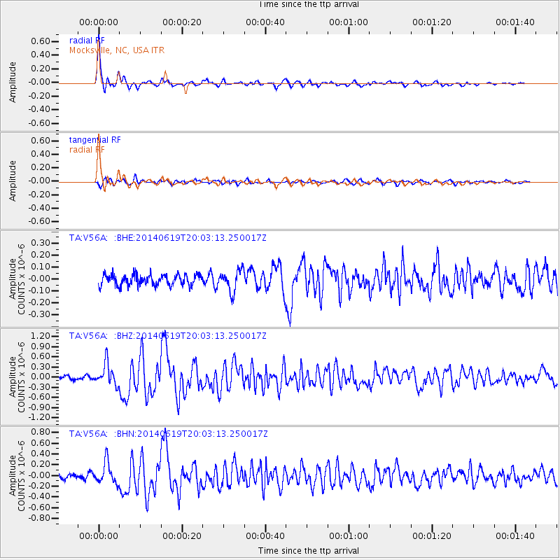
Signal To Noise
| Channel | StoN | STA | LTA |
| TA:V56A: :BHZ:20140619T20:03:13.250017Z | 5.516165 | 3.3066516E-7 | 5.994476E-8 |
| TA:V56A: :BHN:20140619T20:03:13.250017Z | 4.1889997 | 2.0580796E-7 | 4.9130573E-8 |
| TA:V56A: :BHE:20140619T20:03:13.250017Z | 2.048162 | 9.170277E-8 | 4.4773206E-8 |
| Arrivals |
| Ps | 4.9 SECOND |
| PpPs | 15 SECOND |
| PsPs/PpSs | 20 SECOND |


