You are here: Home > Network List > TA - USArray Transportable Network (new EarthScope stations) Stations List
> Station V57A Coltrane Farms, NC, USA > Earthquake Result Viewer
V57A Coltrane Farms, NC, USA - Earthquake Result Viewer

| Earthquake location: |
Near Coast Of Northern Chile |
| Earthquake latitude/longitude: |
-19.8/-70.8 |
| Earthquake time(UTC): |
2014/06/19 (170) 19:54:05 GMT |
| Earthquake Depth: |
11 km |
| Earthquake Magnitude: |
5.7 MWB |
| Earthquake Catalog/Contributor: |
NEIC PDE/NEIC COMCAT |
|
| Network: |
TA USArray Transportable Network (new EarthScope stations) |
| Station: |
V57A Coltrane Farms, NC, USA |
| Lat/Lon: |
35.89 N/79.78 W |
| Elevation: |
223 m |
|
| Distance: |
56.1 deg |
| Az: |
351.245 deg |
| Baz: |
169.837 deg |
| Ray Param: |
0.06438418 |
| Estimated Moho Depth: |
37.0 km |
| Estimated Crust Vp/Vs: |
1.68 |
| Assumed Crust Vp: |
6.565 km/s |
| Estimated Crust Vs: |
3.902 km/s |
| Estimated Crust Poisson's Ratio: |
0.23 |
|
| Radial Match: |
92.1613 % |
| Radial Bump: |
369 |
| Transverse Match: |
79.14308 % |
| Transverse Bump: |
400 |
| SOD ConfigId: |
739768 |
| Insert Time: |
2014-07-03 20:46:43.293 +0000 |
| GWidth: |
2.5 |
| Max Bumps: |
400 |
| Tol: |
0.001 |
|
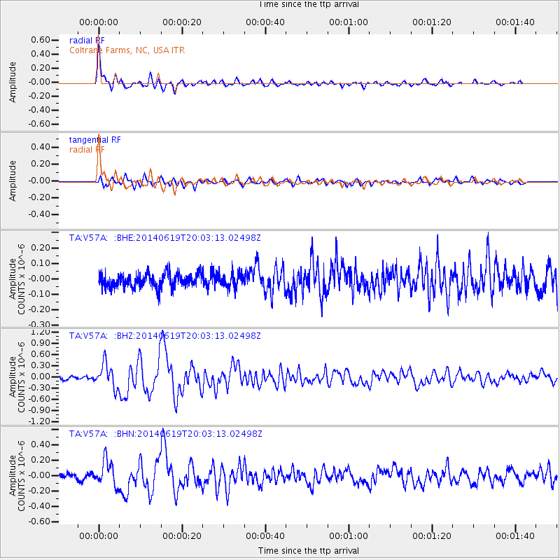
Signal To Noise
| Channel | StoN | STA | LTA |
| TA:V57A: :BHZ:20140619T20:03:13.02498Z | 6.6705027 | 3.2747985E-7 | 4.9093728E-8 |
| TA:V57A: :BHN:20140619T20:03:13.02498Z | 4.7635307 | 1.7204285E-7 | 3.6116667E-8 |
| TA:V57A: :BHE:20140619T20:03:13.02498Z | 0.98833823 | 4.435998E-8 | 4.4883397E-8 |
| Arrivals |
| Ps | 4.1 SECOND |
| PpPs | 14 SECOND |
| PsPs/PpSs | 18 SECOND |


