You are here: Home > Network List > TA - USArray Transportable Network (new EarthScope stations) Stations List
> Station W60A Pink Hill, NC, USA > Earthquake Result Viewer
W60A Pink Hill, NC, USA - Earthquake Result Viewer

| Earthquake location: |
Near Coast Of Northern Chile |
| Earthquake latitude/longitude: |
-19.8/-70.8 |
| Earthquake time(UTC): |
2014/06/19 (170) 19:54:05 GMT |
| Earthquake Depth: |
11 km |
| Earthquake Magnitude: |
5.7 MWB |
| Earthquake Catalog/Contributor: |
NEIC PDE/NEIC COMCAT |
|
| Network: |
TA USArray Transportable Network (new EarthScope stations) |
| Station: |
W60A Pink Hill, NC, USA |
| Lat/Lon: |
35.05 N/77.71 W |
| Elevation: |
30 m |
|
| Distance: |
55.0 deg |
| Az: |
353.103 deg |
| Baz: |
172.08 deg |
| Ray Param: |
0.065098055 |
| Estimated Moho Depth: |
12.5 km |
| Estimated Crust Vp/Vs: |
2.10 |
| Assumed Crust Vp: |
6.565 km/s |
| Estimated Crust Vs: |
3.13 km/s |
| Estimated Crust Poisson's Ratio: |
0.35 |
|
| Radial Match: |
92.027405 % |
| Radial Bump: |
400 |
| Transverse Match: |
76.74472 % |
| Transverse Bump: |
400 |
| SOD ConfigId: |
739768 |
| Insert Time: |
2014-07-03 20:47:20.691 +0000 |
| GWidth: |
2.5 |
| Max Bumps: |
400 |
| Tol: |
0.001 |
|
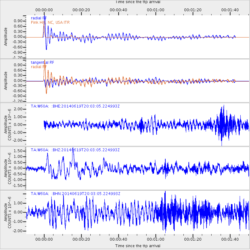
Signal To Noise
| Channel | StoN | STA | LTA |
| TA:W60A: :BHZ:20140619T20:03:05.224993Z | 4.844894 | 5.037138E-7 | 1.0396797E-7 |
| TA:W60A: :BHN:20140619T20:03:05.224993Z | 3.0340748 | 7.0744477E-7 | 2.3316655E-7 |
| TA:W60A: :BHE:20140619T20:03:05.224993Z | 1.171302 | 3.1274746E-7 | 2.670084E-7 |
| Arrivals |
| Ps | 2.2 SECOND |
| PpPs | 5.6 SECOND |
| PsPs/PpSs | 7.8 SECOND |


