You are here: Home > Network List > UU - University of Utah Regional Network Stations List
> Station KNB Kanab, UT, USA > Earthquake Result Viewer
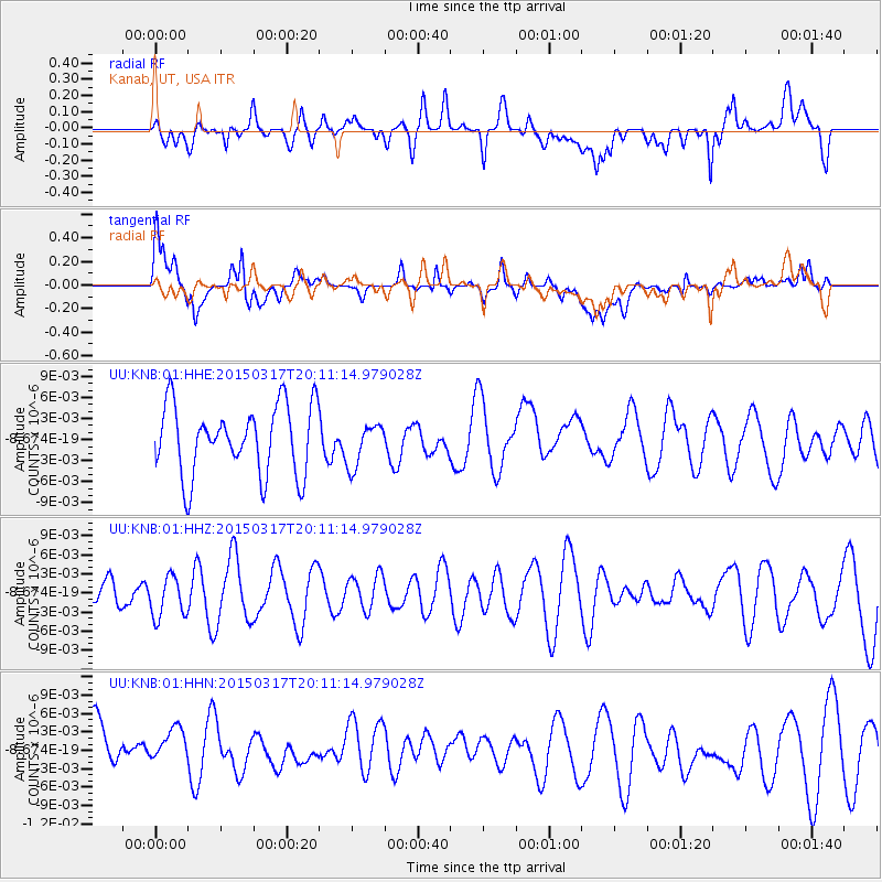
KNB Kanab, UT, USA - Earthquake Result Viewer
*The percent match for this event was below the threshold and hence no stack was calculated.
| Earthquake location: |
Kuril Islands |
| Earthquake latitude/longitude: |
43.5/146.2 |
| Earthquake time(UTC): |
2015/03/17 (076) 20:00:27 GMT |
| Earthquake Depth: |
80 km |
| Earthquake Magnitude: |
4.3 mb |
| Earthquake Catalog/Contributor: |
ISC/ISC |
|
| Network: |
UU University of Utah Regional Network |
| Station: |
KNB Kanab, UT, USA |
| Lat/Lon: |
37.02 N/112.82 W |
| Elevation: |
1715 m |
|
| Distance: |
72.5 deg |
| Az: |
55.464 deg |
| Baz: |
311.503 deg |
| Ray Param: |
$rayparam |
*The percent match for this event was below the threshold and hence was not used in the summary stack. |
|
| Radial Match: |
45.132538 % |
| Radial Bump: |
400 |
| Transverse Match: |
46.781017 % |
| Transverse Bump: |
400 |
| SOD ConfigId: |
7422571 |
| Insert Time: |
2019-04-17 19:29:01.208 +0000 |
| GWidth: |
2.5 |
| Max Bumps: |
400 |
| Tol: |
0.001 |
|
Signal To Noise
| Channel | StoN | STA | LTA |
| UU:KNB:01:HHZ:20150317T20:11:14.979028Z | 0.6292595 | 3.2153147E-9 | 5.10968E-9 |
| UU:KNB:01:HHN:20150317T20:11:14.979028Z | 0.87732226 | 4.4673403E-9 | 5.0920175E-9 |
| UU:KNB:01:HHE:20150317T20:11:14.979028Z | 0.62505835 | 3.0789487E-9 | 4.925858E-9 |
| Arrivals |
| Ps | |
| PpPs | |
| PsPs/PpSs | |


