You are here: Home > Network List > TA - USArray Transportable Network (new EarthScope stations) Stations List
> Station Z56A Williston, SC, USA > Earthquake Result Viewer
Z56A Williston, SC, USA - Earthquake Result Viewer

| Earthquake location: |
Near Coast Of Northern Chile |
| Earthquake latitude/longitude: |
-19.8/-70.8 |
| Earthquake time(UTC): |
2014/06/19 (170) 19:54:05 GMT |
| Earthquake Depth: |
11 km |
| Earthquake Magnitude: |
5.7 MWB |
| Earthquake Catalog/Contributor: |
NEIC PDE/NEIC COMCAT |
|
| Network: |
TA USArray Transportable Network (new EarthScope stations) |
| Station: |
Z56A Williston, SC, USA |
| Lat/Lon: |
33.33 N/81.37 W |
| Elevation: |
81 m |
|
| Distance: |
53.8 deg |
| Az: |
349.062 deg |
| Baz: |
167.681 deg |
| Ray Param: |
0.06584709 |
| Estimated Moho Depth: |
36.5 km |
| Estimated Crust Vp/Vs: |
1.74 |
| Assumed Crust Vp: |
6.565 km/s |
| Estimated Crust Vs: |
3.773 km/s |
| Estimated Crust Poisson's Ratio: |
0.25 |
|
| Radial Match: |
93.05549 % |
| Radial Bump: |
400 |
| Transverse Match: |
76.15288 % |
| Transverse Bump: |
400 |
| SOD ConfigId: |
739768 |
| Insert Time: |
2014-07-03 20:48:22.847 +0000 |
| GWidth: |
2.5 |
| Max Bumps: |
400 |
| Tol: |
0.001 |
|
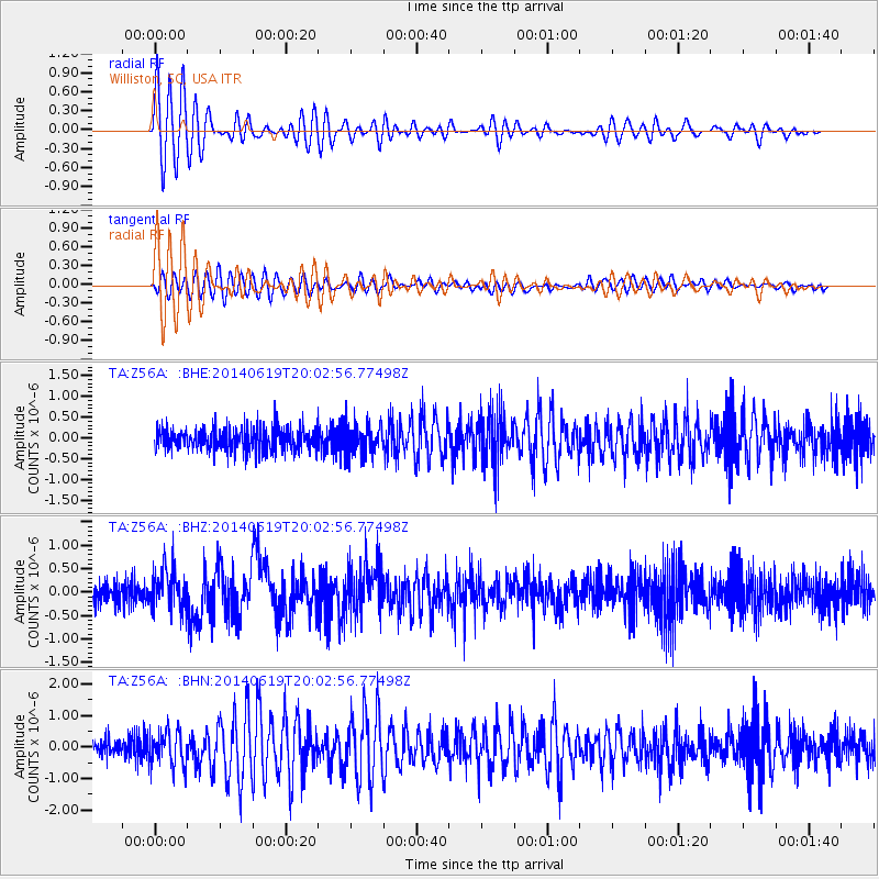
Signal To Noise
| Channel | StoN | STA | LTA |
| TA:Z56A: :BHZ:20140619T20:02:56.77498Z | 1.723801 | 4.2896545E-7 | 2.4884858E-7 |
| TA:Z56A: :BHN:20140619T20:02:56.77498Z | 2.161352 | 5.5655124E-7 | 2.5750143E-7 |
| TA:Z56A: :BHE:20140619T20:02:56.77498Z | 1.3241901 | 3.7252374E-7 | 2.8132195E-7 |
| Arrivals |
| Ps | 4.4 SECOND |
| PpPs | 14 SECOND |
| PsPs/PpSs | 19 SECOND |


