You are here: Home > Network List > II - Global Seismograph Network (GSN - IRIS/IDA) Stations List
> Station WRAB Tennant Creek, NT, Australia > Earthquake Result Viewer
WRAB Tennant Creek, NT, Australia - Earthquake Result Viewer
| Earthquake location: |
Southern Xinjiang, China |
| Earthquake latitude/longitude: |
35.5/81.5 |
| Earthquake time(UTC): |
2008/03/20 (080) 22:32:57 GMT |
| Earthquake Depth: |
10 km |
| Earthquake Magnitude: |
6.3 MB, 7.3 MS, 7.2 MW, 7.1 MW |
| Earthquake Catalog/Contributor: |
WHDF/NEIC |
|
| Network: |
II Global Seismograph Network (GSN - IRIS/IDA) |
| Station: |
WRAB Tennant Creek, NT, Australia |
| Lat/Lon: |
19.93 S/134.36 E |
| Elevation: |
366 m |
|
| Distance: |
74.5 deg |
| Az: |
128.863 deg |
| Baz: |
317.516 deg |
| Ray Param: |
0.052294698 |
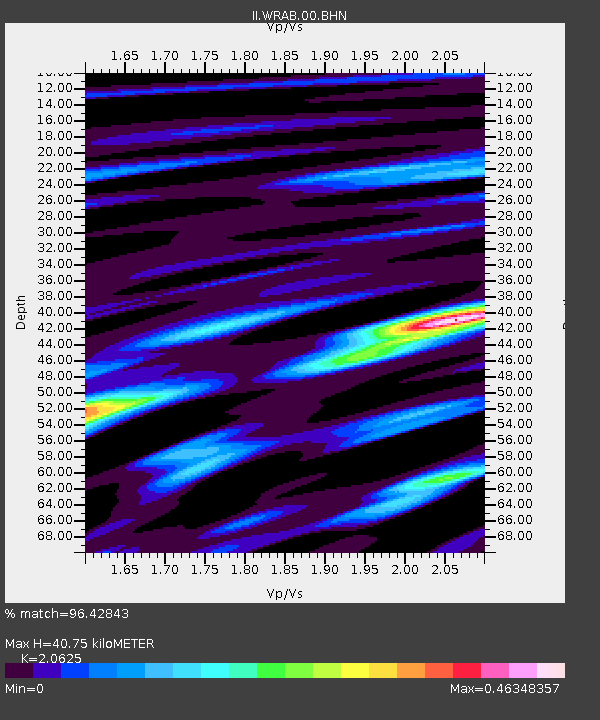
| Estimated Moho Depth: |
40.75 km |
| Estimated Crust Vp/Vs: |
2.06 |
| Assumed Crust Vp: |
6.642 km/s |
| Estimated Crust Vs: |
3.22 km/s |
| Estimated Crust Poisson's Ratio: |
0.35 |
|
| Radial Match: |
96.42843 % |
| Radial Bump: |
347 |
| Transverse Match: |
88.56055 % |
| Transverse Bump: |
400 |
| SOD ConfigId: |
2564 |
| Insert Time: |
2010-03-01 23:13:32.327 +0000 |
| GWidth: |
2.5 |
| Max Bumps: |
400 |
| Tol: |
0.001 |
|
Signal To Noise
| Channel | StoN | STA | LTA |
| II:WRAB:00:BHN:20080320T22:44:05.20002Z | 1.6363552 | 3.2548255E-7 | 1.9890702E-7 |
| II:WRAB:00:BHE:20080320T22:44:05.20002Z | 1.7965608 | 2.5307534E-7 | 1.4086656E-7 |
| II:WRAB:00:BHZ:20080320T22:44:05.20002Z | 2.5868967 | 9.800747E-7 | 3.7886116E-7 |
| Arrivals |
| Ps | 6.7 SECOND |
| PpPs | 18 SECOND |
| PsPs/PpSs | 25 SECOND |


