You are here: Home > Network List > AK - Alaska Regional Network Stations List
> Station MDM Murphy Dome > Earthquake Result Viewer
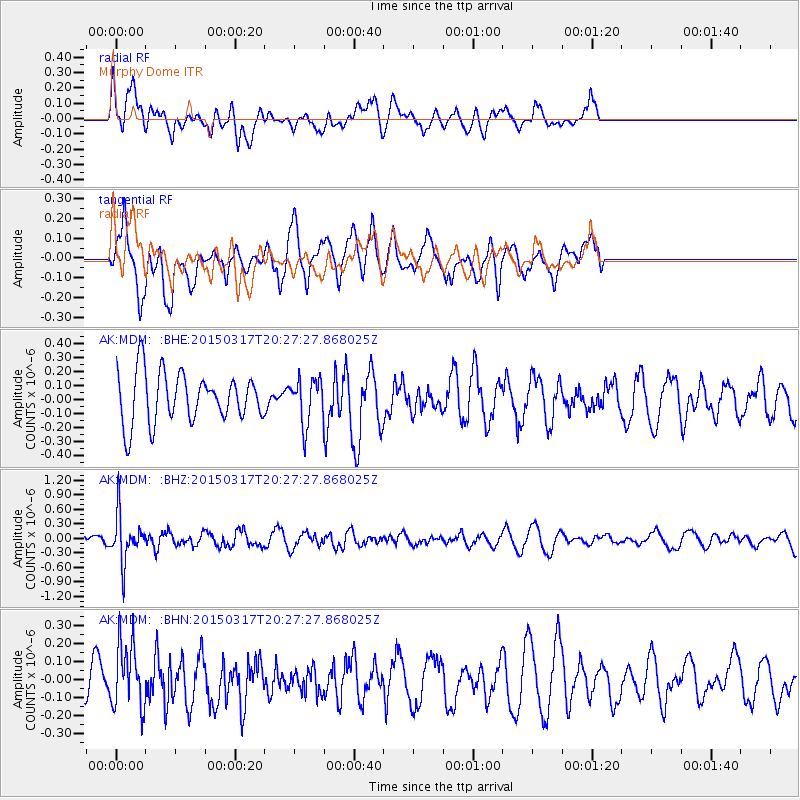
MDM Murphy Dome - Earthquake Result Viewer
*The percent match for this event was below the threshold and hence no stack was calculated.
| Earthquake location: |
Fiji Islands Region |
| Earthquake latitude/longitude: |
-17.8/-178.6 |
| Earthquake time(UTC): |
2015/03/17 (076) 20:16:19 GMT |
| Earthquake Depth: |
556 km |
| Earthquake Magnitude: |
5.5 MWW, 5.6 MWC, 5.6 MWB |
| Earthquake Catalog/Contributor: |
NEIC PDE/NEIC COMCAT |
|
| Network: |
AK Alaska Regional Network |
| Station: |
MDM Murphy Dome |
| Lat/Lon: |
64.96 N/148.23 W |
| Elevation: |
634 m |
|
| Distance: |
85.7 deg |
| Az: |
12.449 deg |
| Baz: |
208.847 deg |
| Ray Param: |
$rayparam |
*The percent match for this event was below the threshold and hence was not used in the summary stack. |
|
| Radial Match: |
56.810806 % |
| Radial Bump: |
400 |
| Transverse Match: |
63.874252 % |
| Transverse Bump: |
400 |
| SOD ConfigId: |
7422571 |
| Insert Time: |
2019-04-17 19:31:33.040 +0000 |
| GWidth: |
2.5 |
| Max Bumps: |
400 |
| Tol: |
0.001 |
|
Signal To Noise
| Channel | StoN | STA | LTA |
| AK:MDM: :BHZ:20150317T20:27:27.868025Z | 2.5973094 | 4.942791E-7 | 1.9030429E-7 |
| AK:MDM: :BHN:20150317T20:27:27.868025Z | 1.183403 | 1.8321211E-7 | 1.5481801E-7 |
| AK:MDM: :BHE:20150317T20:27:27.868025Z | 1.0937451 | 1.919373E-7 | 1.7548632E-7 |
| Arrivals |
| Ps | |
| PpPs | |
| PsPs/PpSs | |


