You are here: Home > Network List > II - Global Seismograph Network (GSN - IRIS/IDA) Stations List
> Station WRAB Tennant Creek, NT, Australia > Earthquake Result Viewer
WRAB Tennant Creek, NT, Australia - Earthquake Result Viewer
| Earthquake location: |
Fiji Islands Region |
| Earthquake latitude/longitude: |
-22.0/-179.6 |
| Earthquake time(UTC): |
1994/03/31 (090) 22:40:53 GMT |
| Earthquake Depth: |
591 km |
| Earthquake Magnitude: |
5.9 MB, 6.5 UNKNOWN, 6.5 MW |
| Earthquake Catalog/Contributor: |
WHDF/NEIC |
|
| Network: |
II Global Seismograph Network (GSN - IRIS/IDA) |
| Station: |
WRAB Tennant Creek, NT, Australia |
| Lat/Lon: |
19.93 S/134.36 E |
| Elevation: |
366 m |
|
| Distance: |
42.9 deg |
| Az: |
263.933 deg |
| Baz: |
101.115 deg |
| Ray Param: |
0.06984733 |
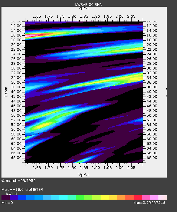
| Estimated Moho Depth: |
16.0 km |
| Estimated Crust Vp/Vs: |
1.60 |
| Assumed Crust Vp: |
6.642 km/s |
| Estimated Crust Vs: |
4.151 km/s |
| Estimated Crust Poisson's Ratio: |
0.18 |
|
| Radial Match: |
95.7952 % |
| Radial Bump: |
400 |
| Transverse Match: |
81.27884 % |
| Transverse Bump: |
400 |
| SOD ConfigId: |
61242 |
| Insert Time: |
2010-03-01 23:14:09.052 +0000 |
| GWidth: |
2.5 |
| Max Bumps: |
400 |
| Tol: |
0.001 |
|
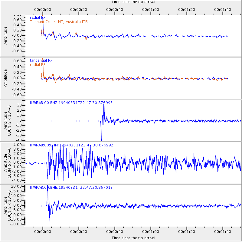
Signal To Noise
| Channel | StoN | STA | LTA |
| II:WRAB:00:BHN:19940331T22:47:30.87699Z | 8.560473 | 1.2575528E-6 | 1.4690224E-7 |
| II:WRAB:00:BHE:19940331T22:47:30.86701Z | 51.995716 | 6.6034827E-6 | 1.270005E-7 |
| II:WRAB:00:BHZ:19940331T22:47:30.87699Z | 81.41447 | 1.3094926E-5 | 1.6084275E-7 |
| Arrivals |
| Ps | 1.6 SECOND |
| PpPs | 5.8 SECOND |
| PsPs/PpSs | 7.4 SECOND |


