You are here: Home > Network List > CN - Canadian National Seismograph Network Stations List
> Station INK INUVIK, NT > Earthquake Result Viewer
INK INUVIK, NT - Earthquake Result Viewer
*The percent match for this event was below the threshold and hence no stack was calculated.
| Earthquake location: |
Fiji Islands Region |
| Earthquake latitude/longitude: |
-17.8/-178.6 |
| Earthquake time(UTC): |
2015/03/17 (076) 20:16:19 GMT |
| Earthquake Depth: |
556 km |
| Earthquake Magnitude: |
5.5 MWW, 5.6 MWC, 5.6 MWB |
| Earthquake Catalog/Contributor: |
NEIC PDE/NEIC COMCAT |
|
| Network: |
CN Canadian National Seismograph Network |
| Station: |
INK INUVIK, NT |
| Lat/Lon: |
68.31 N/133.53 W |
| Elevation: |
44 m |
|
| Distance: |
91.8 deg |
| Az: |
15.261 deg |
| Baz: |
222.408 deg |
| Ray Param: |
$rayparam |
*The percent match for this event was below the threshold and hence was not used in the summary stack. |
|
| Radial Match: |
49.40488 % |
| Radial Bump: |
400 |
| Transverse Match: |
45.99571 % |
| Transverse Bump: |
400 |
| SOD ConfigId: |
7422571 |
| Insert Time: |
2019-04-17 19:33:24.721 +0000 |
| GWidth: |
2.5 |
| Max Bumps: |
400 |
| Tol: |
0.001 |
|
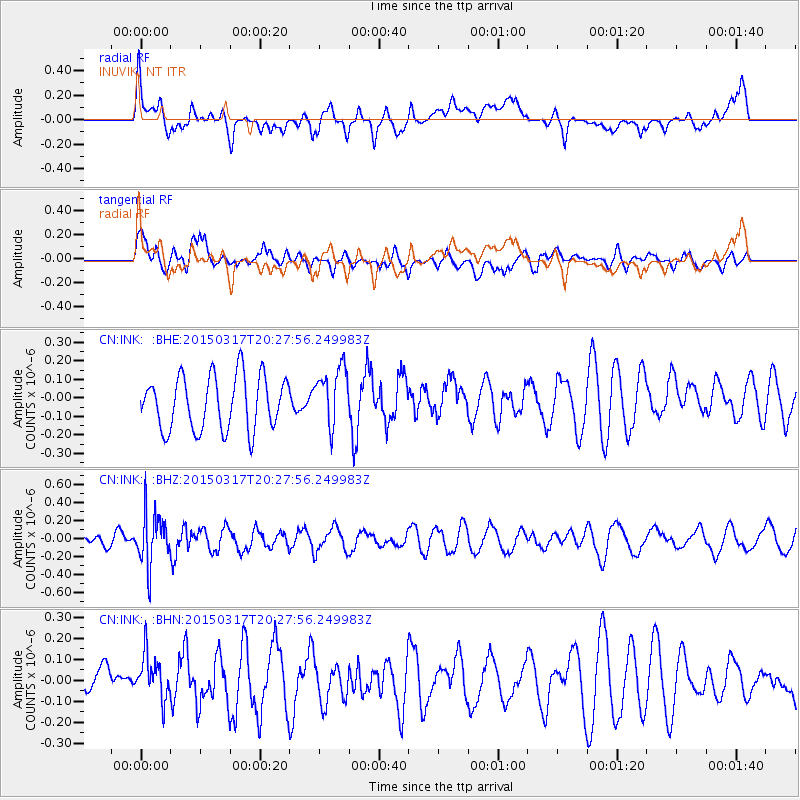
Signal To Noise
| Channel | StoN | STA | LTA |
| CN:INK: :BHZ:20150317T20:27:56.249983Z | 1.9896644 | 2.8555047E-7 | 1.435169E-7 |
| CN:INK: :BHN:20150317T20:27:56.249983Z | 1.3020153 | 1.17371776E-7 | 9.014623E-8 |
| CN:INK: :BHE:20150317T20:27:56.249983Z | 1.0941374 | 1.5801591E-7 | 1.4442054E-7 |
| Arrivals |
| Ps | |
| PpPs | |
| PsPs/PpSs | |


