You are here: Home > Network List > TA - USArray Transportable Network (new EarthScope stations) Stations List
> Station 435B Jarrell, TX, USA > Earthquake Result Viewer
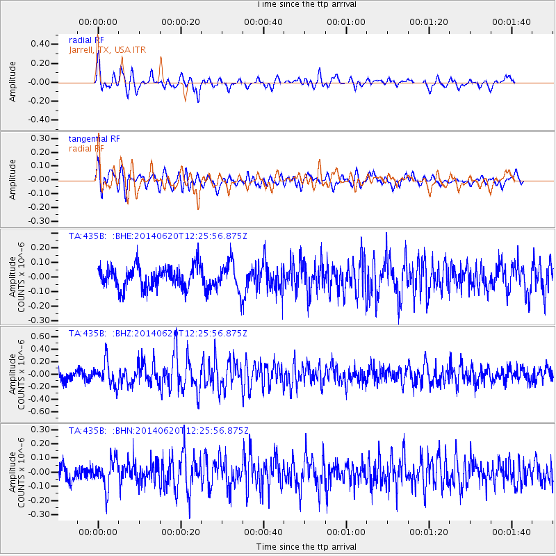
435B Jarrell, TX, USA - Earthquake Result Viewer
*The percent match for this event was below the threshold and hence no stack was calculated.
| Earthquake location: |
Fox Islands, Aleutian Islands |
| Earthquake latitude/longitude: |
51.9/-171.4 |
| Earthquake time(UTC): |
2014/06/20 (171) 12:16:46 GMT |
| Earthquake Depth: |
26 km |
| Earthquake Magnitude: |
5.6 MB, 5.0 ML, 5.1 ML, 5.3 MWB |
| Earthquake Catalog/Contributor: |
NEIC PDE/NEIC COMCAT |
|
| Network: |
TA USArray Transportable Network (new EarthScope stations) |
| Station: |
435B Jarrell, TX, USA |
| Lat/Lon: |
30.78 N/97.58 W |
| Elevation: |
248 m |
|
| Distance: |
56.7 deg |
| Az: |
81.316 deg |
| Baz: |
314.69 deg |
| Ray Param: |
$rayparam |
*The percent match for this event was below the threshold and hence was not used in the summary stack. |
|
| Radial Match: |
69.705345 % |
| Radial Bump: |
400 |
| Transverse Match: |
69.144905 % |
| Transverse Bump: |
400 |
| SOD ConfigId: |
739768 |
| Insert Time: |
2014-07-04 12:49:37.832 +0000 |
| GWidth: |
2.5 |
| Max Bumps: |
400 |
| Tol: |
0.001 |
|
Signal To Noise
| Channel | StoN | STA | LTA |
| TA:435B: :BHZ:20140620T12:25:56.875Z | 2.412864 | 1.982154E-7 | 8.214943E-8 |
| TA:435B: :BHN:20140620T12:25:56.875Z | 2.196229 | 1.01005575E-7 | 4.5990454E-8 |
| TA:435B: :BHE:20140620T12:25:56.875Z | 1.395988 | 1.03728134E-7 | 7.430446E-8 |
| Arrivals |
| Ps | |
| PpPs | |
| PsPs/PpSs | |


