You are here: Home > Network List > TA - USArray Transportable Network (new EarthScope stations) Stations List
> Station E47A Iron Bridge, ON, CAN > Earthquake Result Viewer
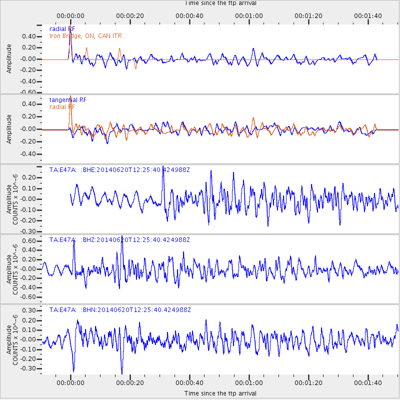
E47A Iron Bridge, ON, CAN - Earthquake Result Viewer
*The percent match for this event was below the threshold and hence no stack was calculated.
| Earthquake location: |
Fox Islands, Aleutian Islands |
| Earthquake latitude/longitude: |
51.9/-171.4 |
| Earthquake time(UTC): |
2014/06/20 (171) 12:16:46 GMT |
| Earthquake Depth: |
26 km |
| Earthquake Magnitude: |
5.6 MB, 5.0 ML, 5.1 ML, 5.3 MWB |
| Earthquake Catalog/Contributor: |
NEIC PDE/NEIC COMCAT |
|
| Network: |
TA USArray Transportable Network (new EarthScope stations) |
| Station: |
E47A Iron Bridge, ON, CAN |
| Lat/Lon: |
46.45 N/83.28 W |
| Elevation: |
246 m |
|
| Distance: |
54.4 deg |
| Az: |
58.17 deg |
| Baz: |
310.482 deg |
| Ray Param: |
$rayparam |
*The percent match for this event was below the threshold and hence was not used in the summary stack. |
|
| Radial Match: |
58.964096 % |
| Radial Bump: |
400 |
| Transverse Match: |
51.245888 % |
| Transverse Bump: |
400 |
| SOD ConfigId: |
739768 |
| Insert Time: |
2014-07-04 12:51:14.875 +0000 |
| GWidth: |
2.5 |
| Max Bumps: |
400 |
| Tol: |
0.001 |
|
Signal To Noise
| Channel | StoN | STA | LTA |
| TA:E47A: :BHZ:20140620T12:25:40.424988Z | 2.7893364 | 1.824048E-7 | 6.539362E-8 |
| TA:E47A: :BHN:20140620T12:25:40.424988Z | 2.1407108 | 1.3638956E-7 | 6.371228E-8 |
| TA:E47A: :BHE:20140620T12:25:40.424988Z | 2.1581452 | 1.1585935E-7 | 5.3684687E-8 |
| Arrivals |
| Ps | |
| PpPs | |
| PsPs/PpSs | |


