You are here: Home > Network List > TA - USArray Transportable Network (new EarthScope stations) Stations List
> Station J05D Fort Rock, OR, USA > Earthquake Result Viewer
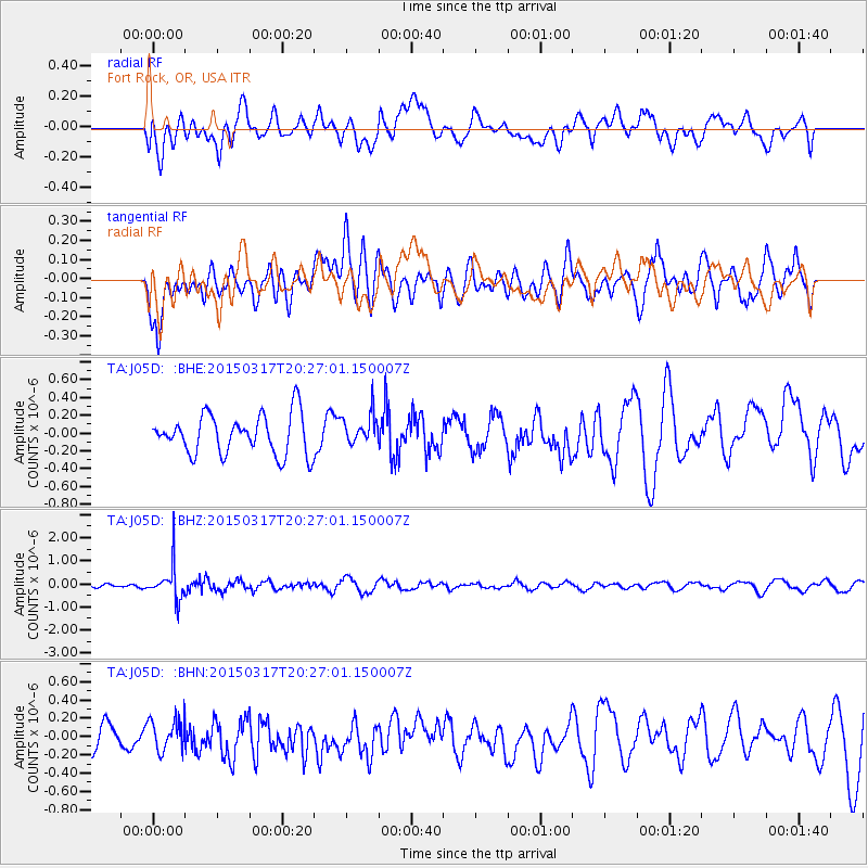
J05D Fort Rock, OR, USA - Earthquake Result Viewer
*The percent match for this event was below the threshold and hence no stack was calculated.
| Earthquake location: |
Fiji Islands Region |
| Earthquake latitude/longitude: |
-17.8/-178.6 |
| Earthquake time(UTC): |
2015/03/17 (076) 20:16:19 GMT |
| Earthquake Depth: |
556 km |
| Earthquake Magnitude: |
5.5 MWW, 5.6 MWC, 5.6 MWB |
| Earthquake Catalog/Contributor: |
NEIC PDE/NEIC COMCAT |
|
| Network: |
TA USArray Transportable Network (new EarthScope stations) |
| Station: |
J05D Fort Rock, OR, USA |
| Lat/Lon: |
43.28 N/121.23 W |
| Elevation: |
1541 m |
|
| Distance: |
80.3 deg |
| Az: |
38.576 deg |
| Baz: |
234.43 deg |
| Ray Param: |
$rayparam |
*The percent match for this event was below the threshold and hence was not used in the summary stack. |
|
| Radial Match: |
35.4968 % |
| Radial Bump: |
400 |
| Transverse Match: |
49.894836 % |
| Transverse Bump: |
400 |
| SOD ConfigId: |
7422571 |
| Insert Time: |
2019-04-17 19:35:36.396 +0000 |
| GWidth: |
2.5 |
| Max Bumps: |
400 |
| Tol: |
0.001 |
|
Signal To Noise
| Channel | StoN | STA | LTA |
| TA:J05D: :BHZ:20150317T20:27:01.150007Z | 9.808832 | 7.3052126E-7 | 7.447587E-8 |
| TA:J05D: :BHN:20150317T20:27:01.150007Z | 0.70436704 | 1.674994E-7 | 2.3780129E-7 |
| TA:J05D: :BHE:20150317T20:27:01.150007Z | 0.7288484 | 1.638893E-7 | 2.2486061E-7 |
| Arrivals |
| Ps | |
| PpPs | |
| PsPs/PpSs | |


