You are here: Home > Network List > TA - USArray Transportable Network (new EarthScope stations) Stations List
> Station Q24A Divide, CO, USA > Earthquake Result Viewer
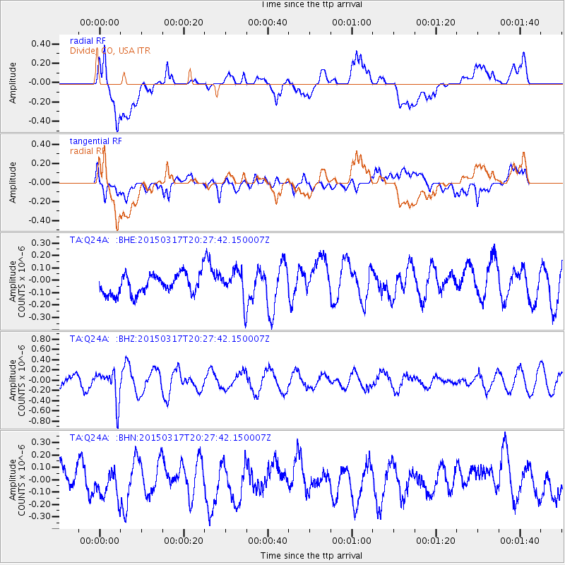
Q24A Divide, CO, USA - Earthquake Result Viewer
*The percent match for this event was below the threshold and hence no stack was calculated.
| Earthquake location: |
Fiji Islands Region |
| Earthquake latitude/longitude: |
-17.8/-178.6 |
| Earthquake time(UTC): |
2015/03/17 (076) 20:16:19 GMT |
| Earthquake Depth: |
556 km |
| Earthquake Magnitude: |
5.5 MWW, 5.6 MWC, 5.6 MWB |
| Earthquake Catalog/Contributor: |
NEIC PDE/NEIC COMCAT |
|
| Network: |
TA USArray Transportable Network (new EarthScope stations) |
| Station: |
Q24A Divide, CO, USA |
| Lat/Lon: |
38.96 N/105.15 W |
| Elevation: |
2775 m |
|
| Distance: |
88.8 deg |
| Az: |
48.361 deg |
| Baz: |
245.949 deg |
| Ray Param: |
$rayparam |
*The percent match for this event was below the threshold and hence was not used in the summary stack. |
|
| Radial Match: |
42.53142 % |
| Radial Bump: |
400 |
| Transverse Match: |
46.86168 % |
| Transverse Bump: |
400 |
| SOD ConfigId: |
7422571 |
| Insert Time: |
2019-04-17 19:35:50.616 +0000 |
| GWidth: |
2.5 |
| Max Bumps: |
400 |
| Tol: |
0.001 |
|
Signal To Noise
| Channel | StoN | STA | LTA |
| TA:Q24A: :BHZ:20150317T20:27:42.150007Z | 2.9006581 | 3.0707167E-7 | 1.0586275E-7 |
| TA:Q24A: :BHN:20150317T20:27:42.150007Z | 0.9657406 | 1.1340054E-7 | 1.174234E-7 |
| TA:Q24A: :BHE:20150317T20:27:42.150007Z | 1.6370704 | 1.3798785E-7 | 8.42895E-8 |
| Arrivals |
| Ps | |
| PpPs | |
| PsPs/PpSs | |


