You are here: Home > Network List > II - Global Seismograph Network (GSN - IRIS/IDA) Stations List
> Station WRAB Tennant Creek, NT, Australia > Earthquake Result Viewer
WRAB Tennant Creek, NT, Australia - Earthquake Result Viewer
| Earthquake location: |
Kuril Islands |
| Earthquake latitude/longitude: |
43.7/147.3 |
| Earthquake time(UTC): |
1994/10/04 (277) 13:22:58 GMT |
| Earthquake Depth: |
33 km |
| Earthquake Magnitude: |
7.4 MB, 8.1 MS, 8.3 UNKNOWN, 8.2 MW |
| Earthquake Catalog/Contributor: |
WHDF/NEIC |
|
| Network: |
II Global Seismograph Network (GSN - IRIS/IDA) |
| Station: |
WRAB Tennant Creek, NT, Australia |
| Lat/Lon: |
19.93 S/134.36 E |
| Elevation: |
366 m |
|
| Distance: |
64.4 deg |
| Az: |
193.535 deg |
| Baz: |
10.393 deg |
| Ray Param: |
0.058871664 |
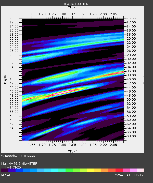
| Estimated Moho Depth: |
46.5 km |
| Estimated Crust Vp/Vs: |
1.79 |
| Assumed Crust Vp: |
6.642 km/s |
| Estimated Crust Vs: |
3.705 km/s |
| Estimated Crust Poisson's Ratio: |
0.27 |
|
| Radial Match: |
99.316666 % |
| Radial Bump: |
202 |
| Transverse Match: |
94.27889 % |
| Transverse Bump: |
400 |
| SOD ConfigId: |
61242 |
| Insert Time: |
2010-03-01 23:15:10.399 +0000 |
| GWidth: |
2.5 |
| Max Bumps: |
400 |
| Tol: |
0.001 |
|
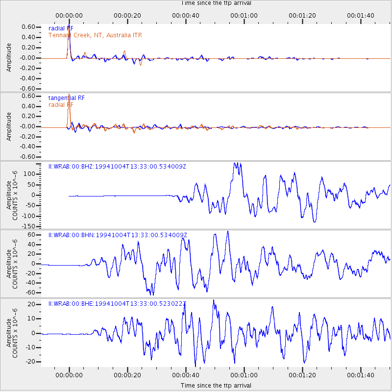
Signal To Noise
| Channel | StoN | STA | LTA |
| II:WRAB:00:BHN:19941004T13:33:00.534009Z | 4.2822595 | 1.3578488E-6 | 3.1708697E-7 |
| II:WRAB:00:BHE:19941004T13:33:00.523022Z | 1.7282645 | 3.566278E-7 | 2.0635025E-7 |
| II:WRAB:00:BHZ:19941004T13:33:00.534009Z | 4.024607 | 1.9844958E-6 | 4.930906E-7 |
| Arrivals |
| Ps | 5.8 SECOND |
| PpPs | 19 SECOND |
| PsPs/PpSs | 24 SECOND |


