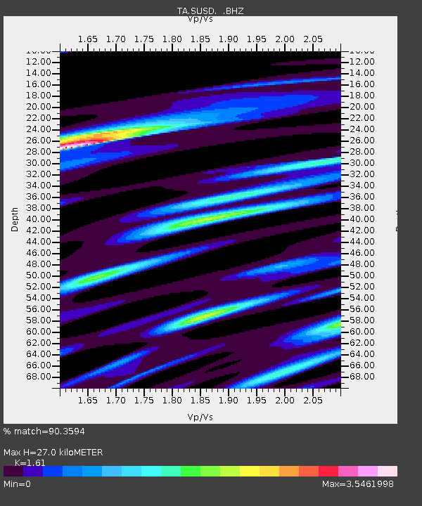
SUSD Miller, SD, USA - Earthquake Result Viewer

Earthquake location: Fox Islands, Aleutian Islands
Earthquake latitude/longitude: 51.9/-171.4
Earthquake time(UTC): 2014/06/20 (171) 12:16:46 GMT
Earthquake Depth: 26 km
Earthquake Magnitude: 5.6 MB, 5.0 ML, 5.1 ML, 5.3 MWB
Earthquake Catalog/Contributor: NEIC PDE/NEIC COMCAT
Network: TA USArray Transportable Network (new EarthScope stations)
Station: SUSD Miller, SD, USA
Lat/Lon: 44.44 N/98.96 W
Elevation: 520 m
Distance: 47.0 deg
Az: 69.026 deg
Baz: 306.214 deg
Ray Param: 0.07024464
Estimated Moho Depth: 27.0 km
Estimated Crust Vp/Vs: 1.61
Assumed Crust Vp: 6.53 km/s
Estimated Crust Vs: 4.056 km/s
Estimated Crust Poisson's Ratio: 0.19
Radial Match: 90.3594 %
Radial Bump: 400
Transverse Match: 90.56602 %
Transverse Bump: 400
SOD ConfigId: 739768
Insert Time: 2014-07-04 13:05:04.714 +0000
GWidth: 2.5
Max Bumps: 400
Tol: 0.001

Signal To Noise

ChannelStoNSTALTA
TA:SUSD: :BHZ:20140620T12:24:44.524994Z6.98860845.082176E-77.272086E-8
TA:SUSD: :BHN:20140620T12:24:44.524994Z4.21611833.4965566E-78.293307E-8
TA:SUSD: :BHE:20140620T12:24:44.524994Z6.361875.691152E-78.945722E-8
Arrivals
Ps2.7 SECOND
PpPs10 SECOND
PsPs/PpSs13 SECOND