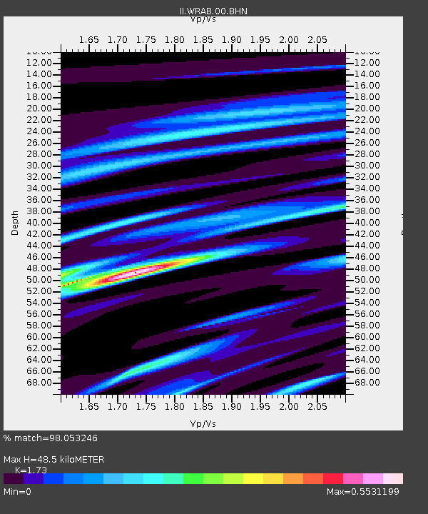
WRAB Tennant Creek, NT, Australia - Earthquake Result Viewer
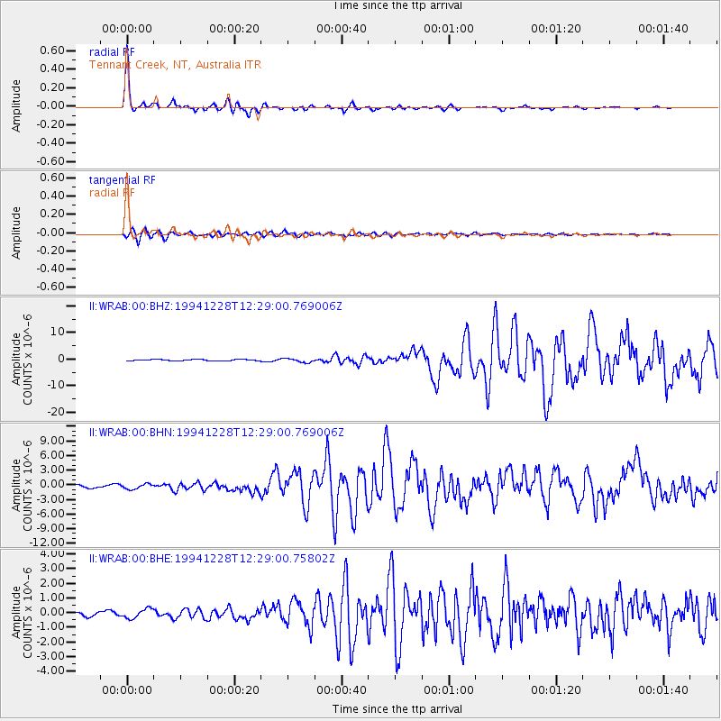
Earthquake location: Off East Coast Of Honshu, Japan
Earthquake latitude/longitude: 40.5/143.5
Earthquake time(UTC): 1994/12/28 (362) 12:19:23 GMT
Earthquake Depth: 33 km
Earthquake Magnitude: 6.4 MB, 7.5 MS, 7.2 UNKNOWN, 7.7 MW
Earthquake Catalog/Contributor: WHDF/NEIC
Network: II Global Seismograph Network (GSN - IRIS/IDA)
Station: WRAB Tennant Creek, NT, Australia
Lat/Lon: 19.93 S/134.36 E
Elevation: 366 m
Distance: 60.7 deg
Az: 189.861 deg
Baz: 7.984 deg
Ray Param: 0.06132152
Estimated Moho Depth: 48.5 km
Estimated Crust Vp/Vs: 1.73
Assumed Crust Vp: 6.642 km/s
Estimated Crust Vs: 3.839 km/s
Estimated Crust Poisson's Ratio: 0.25
Radial Match: 98.053246 %
Radial Bump: 241
Transverse Match: 90.08762 %
Transverse Bump: 400
SOD ConfigId: 61242
Insert Time: 2010-03-01 23:15:29.080 +0000
GWidth: 2.5
Max Bumps: 400
Tol: 0.001

Signal To Noise

ChannelStoNSTALTA
II:WRAB:00:BHN:19941228T12:29:00.769006Z2.4506065.155968E-72.1039564E-7
II:WRAB:00:BHE:19941228T12:29:00.75802Z2.28309153.2253067E-71.4126925E-7
II:WRAB:00:BHZ:19941228T12:29:00.769006Z2.88622747.5040384E-72.5999472E-7
Arrivals
Ps5.6 SECOND
PpPs19 SECOND
PsPs/PpSs25 SECOND