You are here: Home > Network List > TA - USArray Transportable Network (new EarthScope stations) Stations List
> Station V56A Mocksville, NC, USA > Earthquake Result Viewer
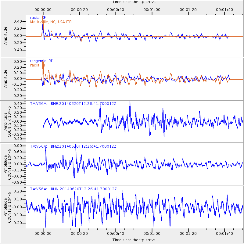
V56A Mocksville, NC, USA - Earthquake Result Viewer
*The percent match for this event was below the threshold and hence no stack was calculated.
| Earthquake location: |
Fox Islands, Aleutian Islands |
| Earthquake latitude/longitude: |
51.9/-171.4 |
| Earthquake time(UTC): |
2014/06/20 (171) 12:16:46 GMT |
| Earthquake Depth: |
26 km |
| Earthquake Magnitude: |
5.6 MB, 5.0 ML, 5.1 ML, 5.3 MWB |
| Earthquake Catalog/Contributor: |
NEIC PDE/NEIC COMCAT |
|
| Network: |
TA USArray Transportable Network (new EarthScope stations) |
| Station: |
V56A Mocksville, NC, USA |
| Lat/Lon: |
35.81 N/80.50 W |
| Elevation: |
237 m |
|
| Distance: |
63.3 deg |
| Az: |
65.52 deg |
| Baz: |
316.132 deg |
| Ray Param: |
$rayparam |
*The percent match for this event was below the threshold and hence was not used in the summary stack. |
|
| Radial Match: |
66.60718 % |
| Radial Bump: |
400 |
| Transverse Match: |
56.6246 % |
| Transverse Bump: |
395 |
| SOD ConfigId: |
739768 |
| Insert Time: |
2014-07-04 13:06:31.645 +0000 |
| GWidth: |
2.5 |
| Max Bumps: |
400 |
| Tol: |
0.001 |
|
Signal To Noise
| Channel | StoN | STA | LTA |
| TA:V56A: :BHZ:20140620T12:26:41.700012Z | 4.0458555 | 2.4684692E-7 | 6.1012294E-8 |
| TA:V56A: :BHN:20140620T12:26:41.700012Z | 1.4590794 | 7.4923E-8 | 5.1349502E-8 |
| TA:V56A: :BHE:20140620T12:26:41.700012Z | 2.8683043 | 1.3868288E-7 | 4.835013E-8 |
| Arrivals |
| Ps | |
| PpPs | |
| PsPs/PpSs | |


