You are here: Home > Network List > II - Global Seismograph Network (GSN - IRIS/IDA) Stations List
> Station WRAB Tennant Creek, NT, Australia > Earthquake Result Viewer
WRAB Tennant Creek, NT, Australia - Earthquake Result Viewer
| Earthquake location: |
Kuril Islands |
| Earthquake latitude/longitude: |
44.6/149.4 |
| Earthquake time(UTC): |
1995/12/03 (337) 18:01:08 GMT |
| Earthquake Depth: |
33 km |
| Earthquake Magnitude: |
6.6 MB, 8.0 MS |
| Earthquake Catalog/Contributor: |
WHDF/NEIC |
|
| Network: |
II Global Seismograph Network (GSN - IRIS/IDA) |
| Station: |
WRAB Tennant Creek, NT, Australia |
| Lat/Lon: |
19.93 S/134.36 E |
| Elevation: |
366 m |
|
| Distance: |
65.6 deg |
| Az: |
195.519 deg |
| Baz: |
11.729 deg |
| Ray Param: |
0.05808721 |
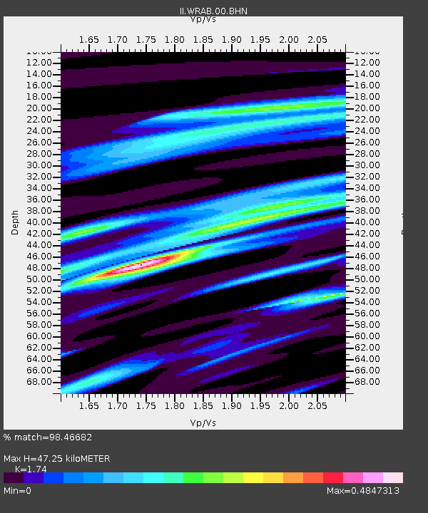
| Estimated Moho Depth: |
47.25 km |
| Estimated Crust Vp/Vs: |
1.74 |
| Assumed Crust Vp: |
6.642 km/s |
| Estimated Crust Vs: |
3.817 km/s |
| Estimated Crust Poisson's Ratio: |
0.25 |
|
| Radial Match: |
98.46682 % |
| Radial Bump: |
288 |
| Transverse Match: |
86.196236 % |
| Transverse Bump: |
400 |
| SOD ConfigId: |
61242 |
| Insert Time: |
2010-03-01 23:15:39.680 +0000 |
| GWidth: |
2.5 |
| Max Bumps: |
400 |
| Tol: |
0.001 |
|

Signal To Noise
| Channel | StoN | STA | LTA |
| II:WRAB:00:BHN:19951203T18:11:18.502014Z | 11.933676 | 1.0753564E-6 | 9.011109E-8 |
| II:WRAB:00:BHE:19951203T18:11:18.541016Z | 2.6692505 | 3.0462473E-7 | 1.141237E-7 |
| II:WRAB:00:BHZ:19951203T18:11:18.502014Z | 18.026058 | 2.3687444E-6 | 1.3140667E-7 |
| Arrivals |
| Ps | 5.5 SECOND |
| PpPs | 19 SECOND |
| PsPs/PpSs | 24 SECOND |


