WRAB Tennant Creek, NT, Australia - Earthquake Result Viewer
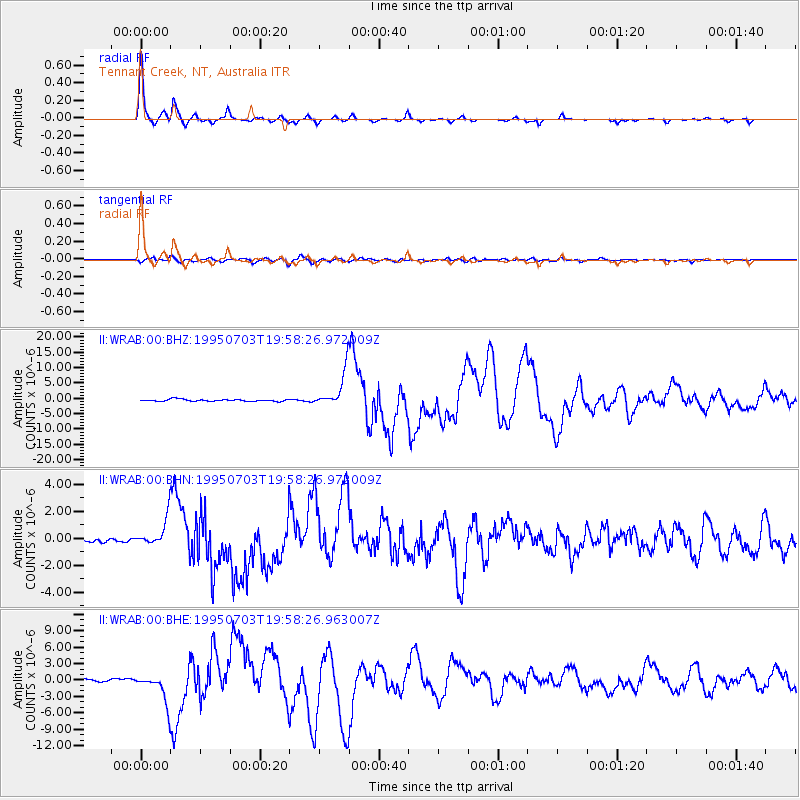
Earthquake location: Kermadec Islands, New Zealand
Earthquake latitude/longitude: -29.2/-177.6
Earthquake time(UTC): 1995/07/03 (184) 19:50:50 GMT
Earthquake Depth: 33 km
Earthquake Magnitude: 6.5 MB, 7.2 MS, 7.2 UNKNOWN, 7.2 MW
Earthquake Catalog/Contributor: WHDF/NEIC
Network: II Global Seismograph Network (GSN - IRIS/IDA)
Station: WRAB Tennant Creek, NT, Australia
Lat/Lon: 19.93 S/134.36 E
Elevation: 366 m
Distance: 44.4 deg
Az: 270.741 deg
Baz: 111.682 deg
Ray Param: 0.07188259
Estimated Moho Depth: 40.5 km
Estimated Crust Vp/Vs: 1.60
Assumed Crust Vp: 6.642 km/s
Estimated Crust Vs: 4.151 km/s
Estimated Crust Poisson's Ratio: 0.18
Radial Match: 98.13165 %
Radial Bump: 224
Transverse Match: 86.36157 %
Transverse Bump: 400
SOD ConfigId: 61242
Insert Time: 2010-03-01 23:15:47.116 +0000
GWidth: 2.5
Max Bumps: 400
Tol: 0.001

Signal To Noise

ChannelStoNSTALTA
II:WRAB:00:BHN:19950703T19:58:26.972009Z5.53238631.0723539E-61.9383207E-7
II:WRAB:00:BHE:19950703T19:58:26.963007Z10.131012.7559608E-62.720322E-7
II:WRAB:00:BHZ:19950703T19:58:26.972009Z18.0301255.705546E-63.1644518E-7
Arrivals
Ps4.0 SECOND
PpPs15 SECOND
PsPs/PpSs19 SECOND