You are here: Home > Network List > II - Global Seismograph Network (GSN - IRIS/IDA) Stations List
> Station WRAB Tennant Creek, NT, Australia > Earthquake Result Viewer
WRAB Tennant Creek, NT, Australia - Earthquake Result Viewer

| Earthquake location: |
Near East Coast Of Honshu, Japan |
| Earthquake latitude/longitude: |
40.2/142.2 |
| Earthquake time(UTC): |
1995/01/06 (006) 22:37:37 GMT |
| Earthquake Depth: |
57 km |
| Earthquake Magnitude: |
6.7 MB, 6.6 UNKNOWN, 7.0 MW |
| Earthquake Catalog/Contributor: |
WHDF/NEIC |
|
| Network: |
II Global Seismograph Network (GSN - IRIS/IDA) |
| Station: |
WRAB Tennant Creek, NT, Australia |
| Lat/Lon: |
19.93 S/134.36 E |
| Elevation: |
366 m |
|
| Distance: |
60.3 deg |
| Az: |
188.542 deg |
| Baz: |
6.943 deg |
| Ray Param: |
0.0614874 |
| Estimated Moho Depth: |
48.0 km |
| Estimated Crust Vp/Vs: |
1.75 |
| Assumed Crust Vp: |
6.642 km/s |
| Estimated Crust Vs: |
3.801 km/s |
| Estimated Crust Poisson's Ratio: |
0.26 |
|
| Radial Match: |
97.6777 % |
| Radial Bump: |
298 |
| Transverse Match: |
87.06331 % |
| Transverse Bump: |
400 |
| SOD ConfigId: |
61242 |
| Insert Time: |
2010-03-01 23:15:54.263 +0000 |
| GWidth: |
2.5 |
| Max Bumps: |
400 |
| Tol: |
0.001 |
|
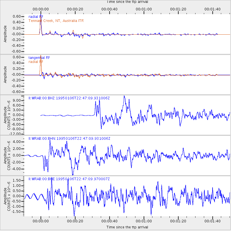
Signal To Noise
| Channel | StoN | STA | LTA |
| II:WRAB:00:BHN:19950106T22:47:09.931006Z | 14.133819 | 2.0002162E-6 | 1.4151988E-7 |
| II:WRAB:00:BHE:19950106T22:47:09.970007Z | 2.856787 | 4.3740883E-7 | 1.5311217E-7 |
| II:WRAB:00:BHZ:19950106T22:47:09.931006Z | 21.63754 | 4.034273E-6 | 1.8644785E-7 |
| Arrivals |
| Ps | 5.7 SECOND |
| PpPs | 19 SECOND |
| PsPs/PpSs | 25 SECOND |


