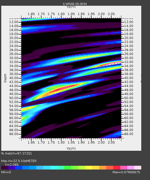
WRAB Tennant Creek, NT, Australia - Earthquake Result Viewer

Earthquake location: Off E. Coast Of N. Island, N.Z.
Earthquake latitude/longitude: -38.0/178.5
Earthquake time(UTC): 1995/02/10 (041) 01:45:04 GMT
Earthquake Depth: 33 km
Earthquake Magnitude: 5.8 MB, 6.4 MS, 6.5 UNKNOWN, 6.3 ML
Earthquake Catalog/Contributor: WHDF/NEIC
Network: II Global Seismograph Network (GSN - IRIS/IDA)
Station: WRAB Tennant Creek, NT, Australia
Lat/Lon: 19.93 S/134.36 E
Elevation: 366 m
Distance: 42.1 deg
Az: 282.567 deg
Baz: 124.921 deg
Ray Param: 0.07328494
Estimated Moho Depth: 32.5 km
Estimated Crust Vp/Vs: 2.07
Assumed Crust Vp: 6.642 km/s
Estimated Crust Vs: 3.216 km/s
Estimated Crust Poisson's Ratio: 0.35
Radial Match: 97.37201 %
Radial Bump: 307
Transverse Match: 81.41581 %
Transverse Bump: 400
SOD ConfigId: 61242
Insert Time: 2010-03-01 23:16:06.414 +0000
GWidth: 2.5
Max Bumps: 400
Tol: 0.001

Signal To Noise

ChannelStoNSTALTA
II:WRAB:00:BHN:19950210T01:52:23.152014Z2.73420763.0842125E-71.1280096E-7
II:WRAB:00:BHE:19950210T01:52:23.143011Z5.0122793.9514524E-77.883544E-8
II:WRAB:00:BHZ:19950210T01:52:23.152991Z6.470157.5571296E-71.1679991E-7
Arrivals
Ps5.5 SECOND
PpPs14 SECOND
PsPs/PpSs20 SECOND