You are here: Home > Network List > TA - USArray Transportable Network (new EarthScope stations) Stations List
> Station J61A Chester, VT, USA > Earthquake Result Viewer
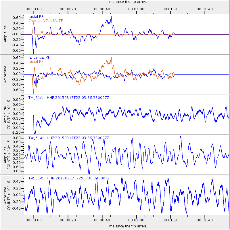
J61A Chester, VT, USA - Earthquake Result Viewer
*The percent match for this event was below the threshold and hence no stack was calculated.
| Earthquake location: |
Kuril Islands |
| Earthquake latitude/longitude: |
44.2/149.2 |
| Earthquake time(UTC): |
2015/03/17 (076) 21:51:37 GMT |
| Earthquake Depth: |
55 km |
| Earthquake Magnitude: |
3.7 mb |
| Earthquake Catalog/Contributor: |
ISC/ISC |
|
| Network: |
TA USArray Transportable Network (new EarthScope stations) |
| Station: |
J61A Chester, VT, USA |
| Lat/Lon: |
43.35 N/72.55 W |
| Elevation: |
253 m |
|
| Distance: |
85.2 deg |
| Az: |
29.198 deg |
| Baz: |
331.269 deg |
| Ray Param: |
$rayparam |
*The percent match for this event was below the threshold and hence was not used in the summary stack. |
|
| Radial Match: |
33.18598 % |
| Radial Bump: |
400 |
| Transverse Match: |
53.561626 % |
| Transverse Bump: |
400 |
| SOD ConfigId: |
7422571 |
| Insert Time: |
2019-04-17 19:43:02.839 +0000 |
| GWidth: |
2.5 |
| Max Bumps: |
400 |
| Tol: |
0.001 |
|
Signal To Noise
| Channel | StoN | STA | LTA |
| TA:J61A: :HHZ:20150317T22:03:36.330007Z | 0.69191974 | 1.9519666E-7 | 2.8210883E-7 |
| TA:J61A: :HHN:20150317T22:03:36.330007Z | 0.7702649 | 3.3039854E-7 | 4.289414E-7 |
| TA:J61A: :HHE:20150317T22:03:36.330007Z | 0.8822577 | 3.5862945E-7 | 4.0649059E-7 |
| Arrivals |
| Ps | |
| PpPs | |
| PsPs/PpSs | |


