You are here: Home > Network List > US - United States National Seismic Network Stations List
> Station EGMT Eagleton, Montana, USA > Earthquake Result Viewer
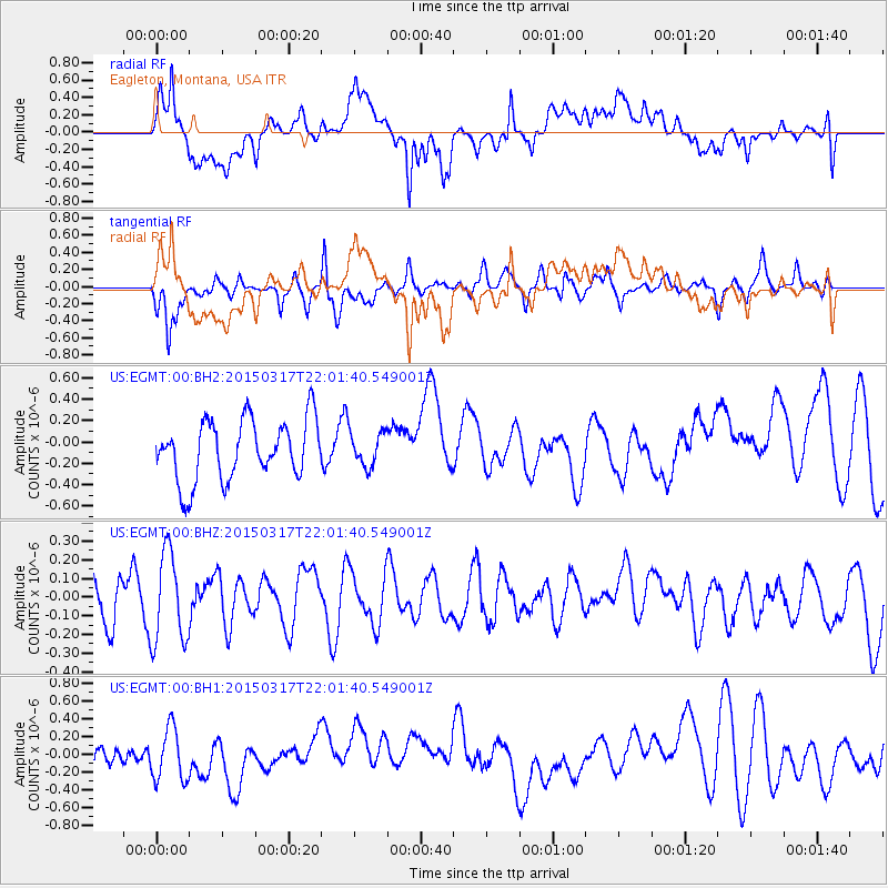
EGMT Eagleton, Montana, USA - Earthquake Result Viewer
*The percent match for this event was below the threshold and hence no stack was calculated.
| Earthquake location: |
Kuril Islands |
| Earthquake latitude/longitude: |
44.2/149.2 |
| Earthquake time(UTC): |
2015/03/17 (076) 21:51:37 GMT |
| Earthquake Depth: |
55 km |
| Earthquake Magnitude: |
3.7 mb |
| Earthquake Catalog/Contributor: |
ISC/ISC |
|
| Network: |
US United States National Seismic Network |
| Station: |
EGMT Eagleton, Montana, USA |
| Lat/Lon: |
48.02 N/109.75 W |
| Elevation: |
1055 m |
|
| Distance: |
65.0 deg |
| Az: |
46.652 deg |
| Baz: |
308.856 deg |
| Ray Param: |
$rayparam |
*The percent match for this event was below the threshold and hence was not used in the summary stack. |
|
| Radial Match: |
51.577904 % |
| Radial Bump: |
400 |
| Transverse Match: |
68.46598 % |
| Transverse Bump: |
390 |
| SOD ConfigId: |
7422571 |
| Insert Time: |
2019-04-17 19:43:52.356 +0000 |
| GWidth: |
2.5 |
| Max Bumps: |
400 |
| Tol: |
0.001 |
|
Signal To Noise
| Channel | StoN | STA | LTA |
| US:EGMT:00:BHZ:20150317T22:01:40.549001Z | 1.4270684 | 2.4206932E-7 | 1.69627E-7 |
| US:EGMT:00:BH1:20150317T22:01:40.549001Z | 1.6882527 | 3.1075297E-7 | 1.8406782E-7 |
| US:EGMT:00:BH2:20150317T22:01:40.549001Z | 0.55595106 | 1.5688414E-7 | 2.8219057E-7 |
| Arrivals |
| Ps | |
| PpPs | |
| PsPs/PpSs | |


