You are here: Home > Network List > II - Global Seismograph Network (GSN - IRIS/IDA) Stations List
> Station WRAB Tennant Creek, NT, Australia > Earthquake Result Viewer
WRAB Tennant Creek, NT, Australia - Earthquake Result Viewer

| Earthquake location: |
Ryukyu Islands, Japan |
| Earthquake latitude/longitude: |
28.1/130.3 |
| Earthquake time(UTC): |
1995/10/19 (292) 02:41:37 GMT |
| Earthquake Depth: |
31 km |
| Earthquake Magnitude: |
6.3 MB, 6.8 MS, 6.6 UNKNOWN, 6.6 MW |
| Earthquake Catalog/Contributor: |
WHDF/NEIC |
|
| Network: |
II Global Seismograph Network (GSN - IRIS/IDA) |
| Station: |
WRAB Tennant Creek, NT, Australia |
| Lat/Lon: |
19.93 S/134.36 E |
| Elevation: |
366 m |
|
| Distance: |
47.9 deg |
| Az: |
174.86 deg |
| Baz: |
355.173 deg |
| Ray Param: |
0.06965025 |
| Estimated Moho Depth: |
53.0 km |
| Estimated Crust Vp/Vs: |
1.60 |
| Assumed Crust Vp: |
6.642 km/s |
| Estimated Crust Vs: |
4.151 km/s |
| Estimated Crust Poisson's Ratio: |
0.18 |
|
| Radial Match: |
96.96798 % |
| Radial Bump: |
281 |
| Transverse Match: |
85.27823 % |
| Transverse Bump: |
400 |
| SOD ConfigId: |
61242 |
| Insert Time: |
2010-03-01 23:16:31.418 +0000 |
| GWidth: |
2.5 |
| Max Bumps: |
400 |
| Tol: |
0.001 |
|
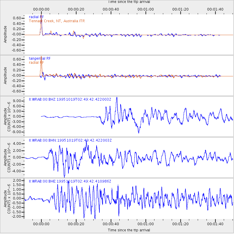
Signal To Noise
| Channel | StoN | STA | LTA |
| II:WRAB:00:BHN:19951019T02:49:42.422003Z | 3.7753398 | 5.6956515E-7 | 1.5086461E-7 |
| II:WRAB:00:BHE:19951019T02:49:42.410986Z | 0.7393643 | 1.5130018E-7 | 2.046355E-7 |
| II:WRAB:00:BHZ:19951019T02:49:42.422003Z | 3.7307525 | 9.235419E-7 | 2.4754843E-7 |
| Arrivals |
| Ps | 5.1 SECOND |
| PpPs | 19 SECOND |
| PsPs/PpSs | 24 SECOND |


