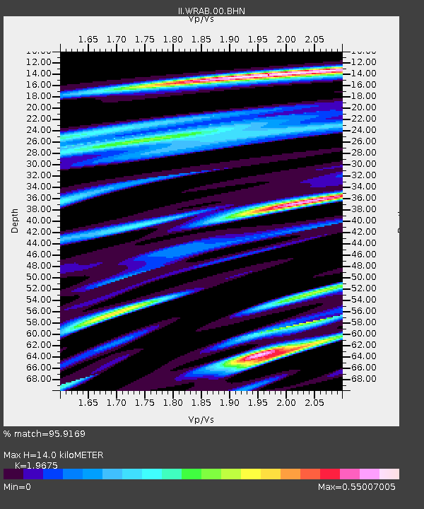
WRAB Tennant Creek, NT, Australia - Earthquake Result Viewer
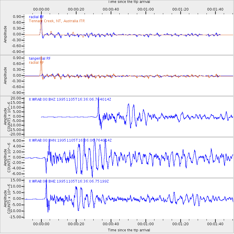
Earthquake location: Southern Sumatra, Indonesia
Earthquake latitude/longitude: -4.9/103.2
Earthquake time(UTC): 1995/11/05 (309) 16:30:00 GMT
Earthquake Depth: 58 km
Earthquake Magnitude: 6.3 MB, 6.1 MS, 5.9 UNKNOWN, 6.3 MW
Earthquake Catalog/Contributor: WHDF/NEIC
Network: II Global Seismograph Network (GSN - IRIS/IDA)
Station: WRAB Tennant Creek, NT, Australia
Lat/Lon: 19.93 S/134.36 E
Elevation: 366 m
Distance: 33.8 deg
Az: 118.933 deg
Baz: 292.053 deg
Ray Param: 0.07792208
Estimated Moho Depth: 14.0 km
Estimated Crust Vp/Vs: 1.97
Assumed Crust Vp: 6.642 km/s
Estimated Crust Vs: 3.376 km/s
Estimated Crust Poisson's Ratio: 0.33
Radial Match: 95.9169 %
Radial Bump: 349
Transverse Match: 92.00744 %
Transverse Bump: 400
SOD ConfigId: 61242
Insert Time: 2010-03-01 23:16:33.110 +0000
GWidth: 2.5
Max Bumps: 400
Tol: 0.001

Signal To Noise

ChannelStoNSTALTA
II:WRAB:00:BHN:19951105T16:36:06.764014Z22.89112.0685773E-69.036601E-8
II:WRAB:00:BHE:19951105T16:36:06.75199Z43.7011874.9010628E-61.1214943E-7
II:WRAB:00:BHZ:19951105T16:36:06.764014Z45.6105546.4691408E-61.4183429E-7
Arrivals
Ps2.2 SECOND
PpPs5.8 SECOND
PsPs/PpSs8.0 SECOND