You are here: Home > Network List > TA - USArray Transportable Network (new EarthScope stations) Stations List
> Station H46A Fife Lake, MI, USA > Earthquake Result Viewer
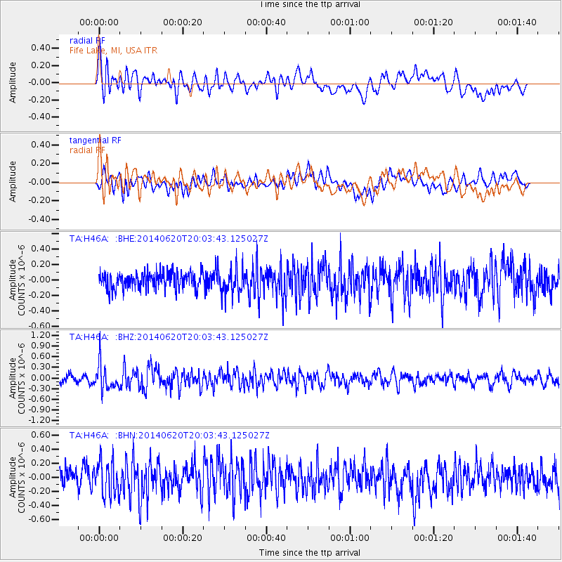
H46A Fife Lake, MI, USA - Earthquake Result Viewer
*The percent match for this event was below the threshold and hence no stack was calculated.
| Earthquake location: |
Near Coast Of Northern Chile |
| Earthquake latitude/longitude: |
-19.8/-70.9 |
| Earthquake time(UTC): |
2014/06/20 (171) 19:53:32 GMT |
| Earthquake Depth: |
14 km |
| Earthquake Magnitude: |
5.5 MB |
| Earthquake Catalog/Contributor: |
NEIC PDE/NEIC COMCAT |
|
| Network: |
TA USArray Transportable Network (new EarthScope stations) |
| Station: |
H46A Fife Lake, MI, USA |
| Lat/Lon: |
44.54 N/85.20 W |
| Elevation: |
329 m |
|
| Distance: |
65.4 deg |
| Az: |
348.766 deg |
| Baz: |
165.138 deg |
| Ray Param: |
$rayparam |
*The percent match for this event was below the threshold and hence was not used in the summary stack. |
|
| Radial Match: |
63.998894 % |
| Radial Bump: |
400 |
| Transverse Match: |
60.070988 % |
| Transverse Bump: |
400 |
| SOD ConfigId: |
739768 |
| Insert Time: |
2014-07-04 20:29:33.378 +0000 |
| GWidth: |
2.5 |
| Max Bumps: |
400 |
| Tol: |
0.001 |
|
Signal To Noise
| Channel | StoN | STA | LTA |
| TA:H46A: :BHZ:20140620T20:03:43.125027Z | 3.9447265 | 3.7589908E-7 | 9.529155E-8 |
| TA:H46A: :BHN:20140620T20:03:43.125027Z | 1.804971 | 2.4486533E-7 | 1.3566164E-7 |
| TA:H46A: :BHE:20140620T20:03:43.125027Z | 1.68376 | 1.7058679E-7 | 1.01313006E-7 |
| Arrivals |
| Ps | |
| PpPs | |
| PsPs/PpSs | |


