You are here: Home > Network List > II - Global Seismograph Network (GSN - IRIS/IDA) Stations List
> Station WRAB Tennant Creek, NT, Australia > Earthquake Result Viewer
WRAB Tennant Creek, NT, Australia - Earthquake Result Viewer
| Earthquake location: |
Kuril Islands |
| Earthquake latitude/longitude: |
45.3/149.9 |
| Earthquake time(UTC): |
1996/02/07 (038) 21:36:45 GMT |
| Earthquake Depth: |
33 km |
| Earthquake Magnitude: |
6.3 MB, 7.0 MS, 7.2 UNKNOWN, 7.1 MW |
| Earthquake Catalog/Contributor: |
WHDF/NEIC |
|
| Network: |
II Global Seismograph Network (GSN - IRIS/IDA) |
| Station: |
WRAB Tennant Creek, NT, Australia |
| Lat/Lon: |
19.93 S/134.36 E |
| Elevation: |
366 m |
|
| Distance: |
66.5 deg |
| Az: |
195.967 deg |
| Baz: |
11.904 deg |
| Ray Param: |
0.057545174 |
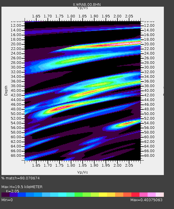
| Estimated Moho Depth: |
19.5 km |
| Estimated Crust Vp/Vs: |
2.05 |
| Assumed Crust Vp: |
6.642 km/s |
| Estimated Crust Vs: |
3.24 km/s |
| Estimated Crust Poisson's Ratio: |
0.34 |
|
| Radial Match: |
98.078674 % |
| Radial Bump: |
211 |
| Transverse Match: |
90.053 % |
| Transverse Bump: |
400 |
| SOD ConfigId: |
6273 |
| Insert Time: |
2010-03-01 23:16:59.624 +0000 |
| GWidth: |
2.5 |
| Max Bumps: |
400 |
| Tol: |
0.001 |
|
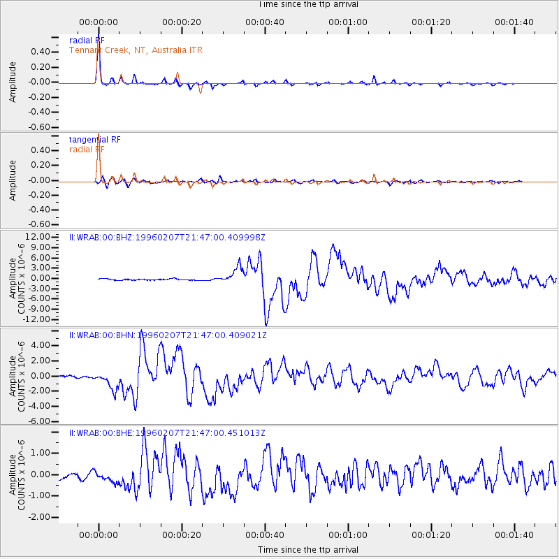
Signal To Noise
| Channel | StoN | STA | LTA |
| II:WRAB:00:BHN:19960207T21:47:00.409021Z | 9.23144 | 1.2338013E-6 | 1.336521E-7 |
| II:WRAB:00:BHE:19960207T21:47:00.451013Z | 2.2990775 | 2.4163575E-7 | 1.0510118E-7 |
| II:WRAB:00:BHZ:19960207T21:47:00.409998Z | 13.217744 | 2.5490738E-6 | 1.9285241E-7 |
| Arrivals |
| Ps | 3.2 SECOND |
| PpPs | 8.6 SECOND |
| PsPs/PpSs | 12 SECOND |


