You are here: Home > Network List > TA - USArray Transportable Network (new EarthScope stations) Stations List
> Station Q53A Leroy, WV, USA > Earthquake Result Viewer
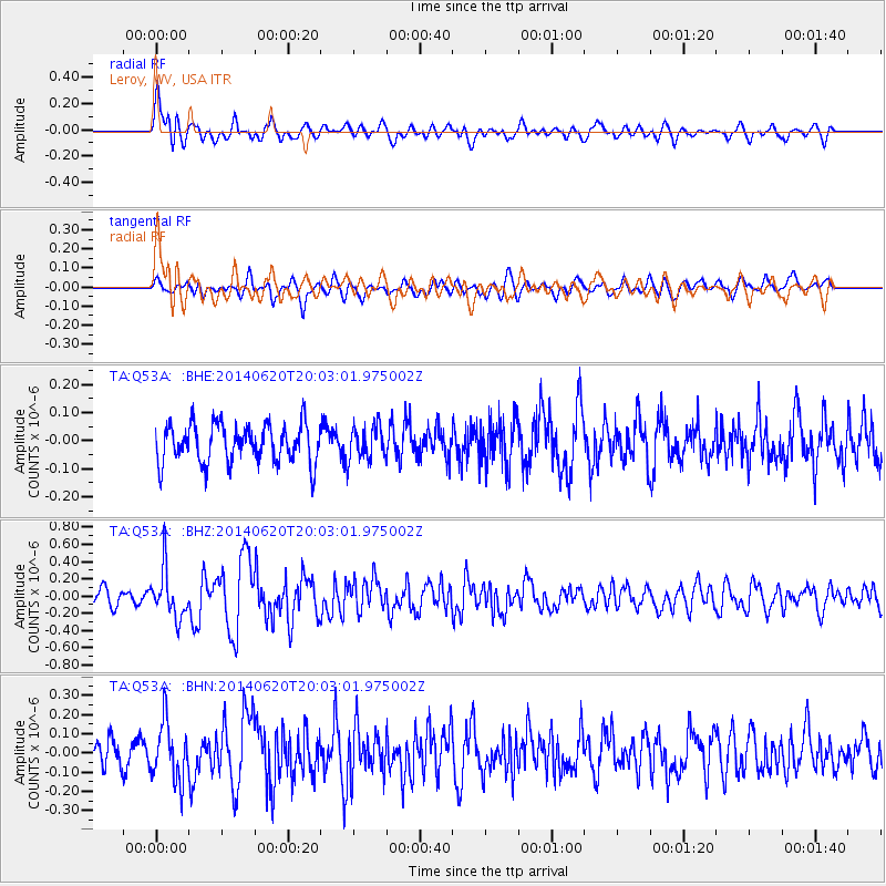
Q53A Leroy, WV, USA - Earthquake Result Viewer
*The percent match for this event was below the threshold and hence no stack was calculated.
| Earthquake location: |
Near Coast Of Northern Chile |
| Earthquake latitude/longitude: |
-19.8/-70.9 |
| Earthquake time(UTC): |
2014/06/20 (171) 19:53:32 GMT |
| Earthquake Depth: |
14 km |
| Earthquake Magnitude: |
5.5 MB |
| Earthquake Catalog/Contributor: |
NEIC PDE/NEIC COMCAT |
|
| Network: |
TA USArray Transportable Network (new EarthScope stations) |
| Station: |
Q53A Leroy, WV, USA |
| Lat/Lon: |
38.86 N/81.53 W |
| Elevation: |
310 m |
|
| Distance: |
59.2 deg |
| Az: |
350.322 deg |
| Baz: |
168.304 deg |
| Ray Param: |
$rayparam |
*The percent match for this event was below the threshold and hence was not used in the summary stack. |
|
| Radial Match: |
67.905334 % |
| Radial Bump: |
400 |
| Transverse Match: |
61.88416 % |
| Transverse Bump: |
400 |
| SOD ConfigId: |
739768 |
| Insert Time: |
2014-07-04 20:38:33.163 +0000 |
| GWidth: |
2.5 |
| Max Bumps: |
400 |
| Tol: |
0.001 |
|
Signal To Noise
| Channel | StoN | STA | LTA |
| TA:Q53A: :BHZ:20140620T20:03:01.975002Z | 3.1598556 | 2.7710837E-7 | 8.7696534E-8 |
| TA:Q53A: :BHN:20140620T20:03:01.975002Z | 2.3388853 | 1.527978E-7 | 6.5329324E-8 |
| TA:Q53A: :BHE:20140620T20:03:01.975002Z | 0.87672913 | 5.993194E-8 | 6.835856E-8 |
| Arrivals |
| Ps | |
| PpPs | |
| PsPs/PpSs | |


