You are here: Home > Network List > TA - USArray Transportable Network (new EarthScope stations) Stations List
> Station Q56A Snyder Ridge, Maysville, WV, USA > Earthquake Result Viewer
Q56A Snyder Ridge, Maysville, WV, USA - Earthquake Result Viewer

| Earthquake location: |
Near Coast Of Northern Chile |
| Earthquake latitude/longitude: |
-19.8/-70.9 |
| Earthquake time(UTC): |
2014/06/20 (171) 19:53:32 GMT |
| Earthquake Depth: |
14 km |
| Earthquake Magnitude: |
5.5 MB |
| Earthquake Catalog/Contributor: |
NEIC PDE/NEIC COMCAT |
|
| Network: |
TA USArray Transportable Network (new EarthScope stations) |
| Station: |
Q56A Snyder Ridge, Maysville, WV, USA |
| Lat/Lon: |
39.04 N/79.19 W |
| Elevation: |
430 m |
|
| Distance: |
59.1 deg |
| Az: |
352.449 deg |
| Baz: |
170.859 deg |
| Ray Param: |
0.062428858 |
| Estimated Moho Depth: |
43.25 km |
| Estimated Crust Vp/Vs: |
1.79 |
| Assumed Crust Vp: |
6.159 km/s |
| Estimated Crust Vs: |
3.45 km/s |
| Estimated Crust Poisson's Ratio: |
0.27 |
|
| Radial Match: |
86.721 % |
| Radial Bump: |
400 |
| Transverse Match: |
68.91415 % |
| Transverse Bump: |
400 |
| SOD ConfigId: |
739768 |
| Insert Time: |
2014-07-04 20:38:45.767 +0000 |
| GWidth: |
2.5 |
| Max Bumps: |
400 |
| Tol: |
0.001 |
|
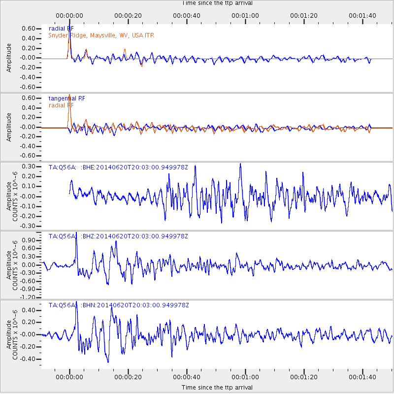
Signal To Noise
| Channel | StoN | STA | LTA |
| TA:Q56A: :BHZ:20140620T20:03:00.949978Z | 5.0196137 | 3.4908848E-7 | 6.9544896E-8 |
| TA:Q56A: :BHN:20140620T20:03:00.949978Z | 5.477254 | 2.0001396E-7 | 3.6517196E-8 |
| TA:Q56A: :BHE:20140620T20:03:00.949978Z | 2.2561102 | 1.03601224E-7 | 4.5920288E-8 |
| Arrivals |
| Ps | 5.8 SECOND |
| PpPs | 19 SECOND |
| PsPs/PpSs | 24 SECOND |


