You are here: Home > Network List > II - Global Seismograph Network (GSN - IRIS/IDA) Stations List
> Station WRAB Tennant Creek, NT, Australia > Earthquake Result Viewer
WRAB Tennant Creek, NT, Australia - Earthquake Result Viewer
| Earthquake location: |
Kuril Islands |
| Earthquake latitude/longitude: |
45.2/148.6 |
| Earthquake time(UTC): |
1996/02/22 (053) 14:59:09 GMT |
| Earthquake Depth: |
133 km |
| Earthquake Magnitude: |
6.2 MB, 6.3 UNKNOWN, 6.3 MW |
| Earthquake Catalog/Contributor: |
WHDF/NEIC |
|
| Network: |
II Global Seismograph Network (GSN - IRIS/IDA) |
| Station: |
WRAB Tennant Creek, NT, Australia |
| Lat/Lon: |
19.93 S/134.36 E |
| Elevation: |
366 m |
|
| Distance: |
66.1 deg |
| Az: |
194.618 deg |
| Baz: |
10.931 deg |
| Ray Param: |
0.05746502 |
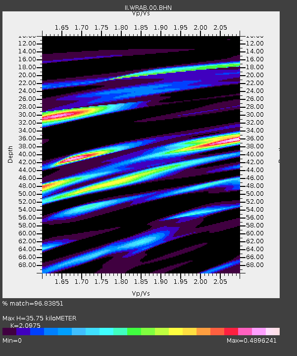
| Estimated Moho Depth: |
35.75 km |
| Estimated Crust Vp/Vs: |
2.10 |
| Assumed Crust Vp: |
6.642 km/s |
| Estimated Crust Vs: |
3.167 km/s |
| Estimated Crust Poisson's Ratio: |
0.35 |
|
| Radial Match: |
96.83851 % |
| Radial Bump: |
398 |
| Transverse Match: |
79.73518 % |
| Transverse Bump: |
400 |
| SOD ConfigId: |
6273 |
| Insert Time: |
2010-03-01 23:17:08.062 +0000 |
| GWidth: |
2.5 |
| Max Bumps: |
400 |
| Tol: |
0.001 |
|

Signal To Noise
| Channel | StoN | STA | LTA |
| II:WRAB:00:BHN:19960222T15:09:11.780017Z | 13.045083 | 1.1875304E-6 | 9.1032796E-8 |
| II:WRAB:00:BHE:19960222T15:09:11.770007Z | 3.4295888 | 3.3745386E-7 | 9.839485E-8 |
| II:WRAB:00:BHZ:19960222T15:09:11.780017Z | 25.89874 | 2.6815687E-6 | 1.035405E-7 |
| Arrivals |
| Ps | 6.1 SECOND |
| PpPs | 16 SECOND |
| PsPs/PpSs | 22 SECOND |


