You are here: Home > Network List > CB - China National Seismic Network Stations List
> Station WHN Wuhantai,Hubei Province > Earthquake Result Viewer
WHN Wuhantai,Hubei Province - Earthquake Result Viewer
| Earthquake location: |
Northern Molucca Sea |
| Earthquake latitude/longitude: |
1.7/126.5 |
| Earthquake time(UTC): |
2015/03/17 (076) 22:12:28 GMT |
| Earthquake Depth: |
42 km |
| Earthquake Magnitude: |
6.6 MO |
| Earthquake Catalog/Contributor: |
NEIC PDE/NEIC ALERT |
|
| Network: |
CB China National Seismic Network |
| Station: |
WHN Wuhantai,Hubei Province |
| Lat/Lon: |
30.54 N/114.35 E |
| Elevation: |
80 m |
|
| Distance: |
31.0 deg |
| Az: |
339.297 deg |
| Baz: |
155.82 deg |
| Ray Param: |
0.07914811 |
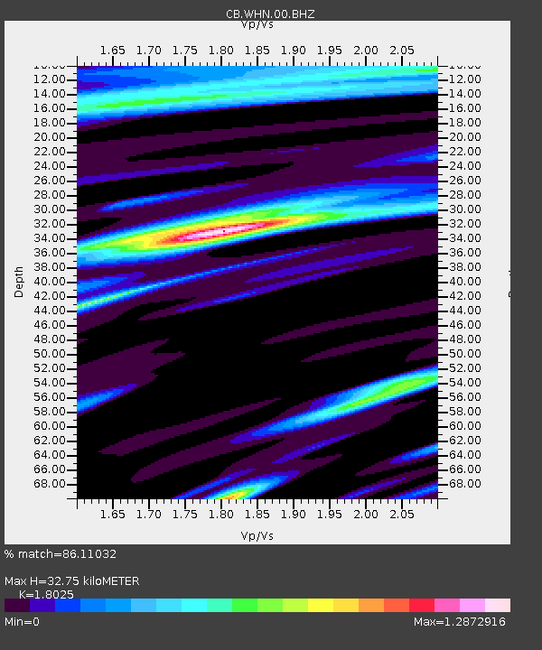
| Estimated Moho Depth: |
32.75 km |
| Estimated Crust Vp/Vs: |
1.80 |
| Assumed Crust Vp: |
6.276 km/s |
| Estimated Crust Vs: |
3.482 km/s |
| Estimated Crust Poisson's Ratio: |
0.28 |
|
| Radial Match: |
86.11032 % |
| Radial Bump: |
382 |
| Transverse Match: |
65.46779 % |
| Transverse Bump: |
400 |
| SOD ConfigId: |
7422571 |
| Insert Time: |
2019-04-17 19:47:09.600 +0000 |
| GWidth: |
2.5 |
| Max Bumps: |
400 |
| Tol: |
0.001 |
|

Signal To Noise
| Channel | StoN | STA | LTA |
| CB:WHN:00:BHZ:20150317T22:18:11.509991Z | 10.713956 | 9.42753E-7 | 8.799299E-8 |
| CB:WHN:00:BHN:20150317T22:18:11.509991Z | 3.908306 | 4.4212516E-7 | 1.131245E-7 |
| CB:WHN:00:BHE:20150317T22:18:11.509991Z | 2.3203647 | 2.1806707E-7 | 9.397966E-8 |
| Arrivals |
| Ps | 4.5 SECOND |
| PpPs | 14 SECOND |
| PsPs/PpSs | 18 SECOND |


