You are here: Home > Network List > CN - Canadian National Seismograph Network Stations List
> Station INK INUVIK, NT > Earthquake Result Viewer
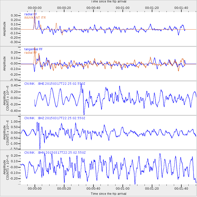
INK INUVIK, NT - Earthquake Result Viewer
*The percent match for this event was below the threshold and hence no stack was calculated.
| Earthquake location: |
Northern Molucca Sea |
| Earthquake latitude/longitude: |
1.7/126.5 |
| Earthquake time(UTC): |
2015/03/17 (076) 22:12:28 GMT |
| Earthquake Depth: |
42 km |
| Earthquake Magnitude: |
6.6 MO |
| Earthquake Catalog/Contributor: |
NEIC PDE/NEIC ALERT |
|
| Network: |
CN Canadian National Seismograph Network |
| Station: |
INK INUVIK, NT |
| Lat/Lon: |
68.31 N/133.53 W |
| Elevation: |
44 m |
|
| Distance: |
92.2 deg |
| Az: |
21.497 deg |
| Baz: |
279.856 deg |
| Ray Param: |
$rayparam |
*The percent match for this event was below the threshold and hence was not used in the summary stack. |
|
| Radial Match: |
51.276524 % |
| Radial Bump: |
400 |
| Transverse Match: |
58.519314 % |
| Transverse Bump: |
400 |
| SOD ConfigId: |
7422571 |
| Insert Time: |
2019-04-17 19:47:13.128 +0000 |
| GWidth: |
2.5 |
| Max Bumps: |
400 |
| Tol: |
0.001 |
|
Signal To Noise
| Channel | StoN | STA | LTA |
| CN:INK: :BHZ:20150317T22:25:02.550Z | 4.043103 | 6.126075E-7 | 1.5151913E-7 |
| CN:INK: :BHN:20150317T22:25:02.550Z | 0.57058215 | 7.3760255E-8 | 1.2927192E-7 |
| CN:INK: :BHE:20150317T22:25:02.550Z | 1.6826562 | 2.6574958E-7 | 1.5793456E-7 |
| Arrivals |
| Ps | |
| PpPs | |
| PsPs/PpSs | |


