You are here: Home > Network List > II - Global Seismograph Network (GSN - IRIS/IDA) Stations List
> Station WRAB Tennant Creek, NT, Australia > Earthquake Result Viewer
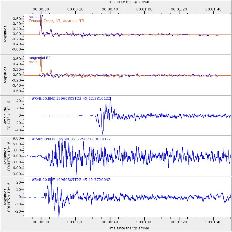
WRAB Tennant Creek, NT, Australia - Earthquake Result Viewer
| Earthquake location: |
Fiji Islands Region |
| Earthquake latitude/longitude: |
-20.7/-178.3 |
| Earthquake time(UTC): |
1996/08/05 (218) 22:38:22 GMT |
| Earthquake Depth: |
550 km |
| Earthquake Magnitude: |
6.4 MB, 7.4 UNKNOWN, 7.3 MW |
| Earthquake Catalog/Contributor: |
WHDF/NEIC |
|
| Network: |
II Global Seismograph Network (GSN - IRIS/IDA) |
| Station: |
WRAB Tennant Creek, NT, Australia |
| Lat/Lon: |
19.93 S/134.36 E |
| Elevation: |
366 m |
|
| Distance: |
44.3 deg |
| Az: |
262.315 deg |
| Baz: |
99.515 deg |
| Ray Param: |
0.069346964 |
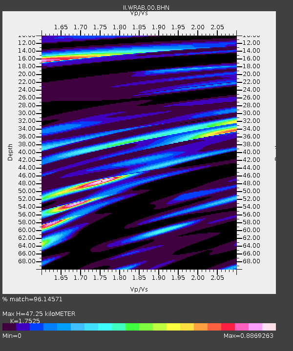
| Estimated Moho Depth: |
47.25 km |
| Estimated Crust Vp/Vs: |
1.75 |
| Assumed Crust Vp: |
6.642 km/s |
| Estimated Crust Vs: |
3.79 km/s |
| Estimated Crust Poisson's Ratio: |
0.26 |
|
| Radial Match: |
96.14571 % |
| Radial Bump: |
356 |
| Transverse Match: |
84.80602 % |
| Transverse Bump: |
400 |
| SOD ConfigId: |
6273 |
| Insert Time: |
2010-03-01 23:17:24.659 +0000 |
| GWidth: |
2.5 |
| Max Bumps: |
400 |
| Tol: |
0.001 |
|
Signal To Noise
| Channel | StoN | STA | LTA |
| II:WRAB:00:BHN:19960805T22:45:12.381012Z | 4.40274 | 1.040024E-6 | 2.36222E-7 |
| II:WRAB:00:BHE:19960805T22:45:12.372009Z | 21.238388 | 6.0347857E-6 | 2.841452E-7 |
| II:WRAB:00:BHZ:19960805T22:45:12.381012Z | 29.520113 | 1.1328834E-5 | 3.8376663E-7 |
| Arrivals |
| Ps | 5.7 SECOND |
| PpPs | 18 SECOND |
| PsPs/PpSs | 24 SECOND |


