You are here: Home > Network List > US - United States National Seismic Network Stations List
> Station MSO Missoula, Montana, USA > Earthquake Result Viewer
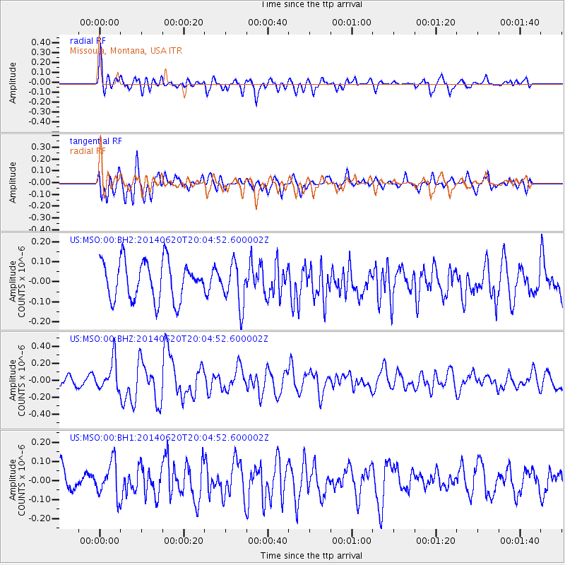
MSO Missoula, Montana, USA - Earthquake Result Viewer
*The percent match for this event was below the threshold and hence no stack was calculated.
| Earthquake location: |
Near Coast Of Northern Chile |
| Earthquake latitude/longitude: |
-19.8/-70.9 |
| Earthquake time(UTC): |
2014/06/20 (171) 19:53:32 GMT |
| Earthquake Depth: |
14 km |
| Earthquake Magnitude: |
5.5 MB |
| Earthquake Catalog/Contributor: |
NEIC PDE/NEIC COMCAT |
|
| Network: |
US United States National Seismic Network |
| Station: |
MSO Missoula, Montana, USA |
| Lat/Lon: |
46.83 N/113.94 W |
| Elevation: |
1264 m |
|
| Distance: |
76.9 deg |
| Az: |
331.215 deg |
| Baz: |
138.679 deg |
| Ray Param: |
$rayparam |
*The percent match for this event was below the threshold and hence was not used in the summary stack. |
|
| Radial Match: |
57.372925 % |
| Radial Bump: |
400 |
| Transverse Match: |
62.568775 % |
| Transverse Bump: |
400 |
| SOD ConfigId: |
739768 |
| Insert Time: |
2014-07-04 20:46:08.783 +0000 |
| GWidth: |
2.5 |
| Max Bumps: |
400 |
| Tol: |
0.001 |
|
Signal To Noise
| Channel | StoN | STA | LTA |
| US:MSO:00:BHZ:20140620T20:04:52.600002Z | 2.326401 | 1.8069926E-7 | 7.767331E-8 |
| US:MSO:00:BH1:20140620T20:04:52.600002Z | 1.5057012 | 9.250813E-8 | 6.143857E-8 |
| US:MSO:00:BH2:20140620T20:04:52.600002Z | 1.1391788 | 1.09457176E-7 | 9.608428E-8 |
| Arrivals |
| Ps | |
| PpPs | |
| PsPs/PpSs | |


