You are here: Home > Network List > UW - Pacific Northwest Regional Seismic Network Stations List
> Station UMAT Pilot Rock, OR, USA > Earthquake Result Viewer
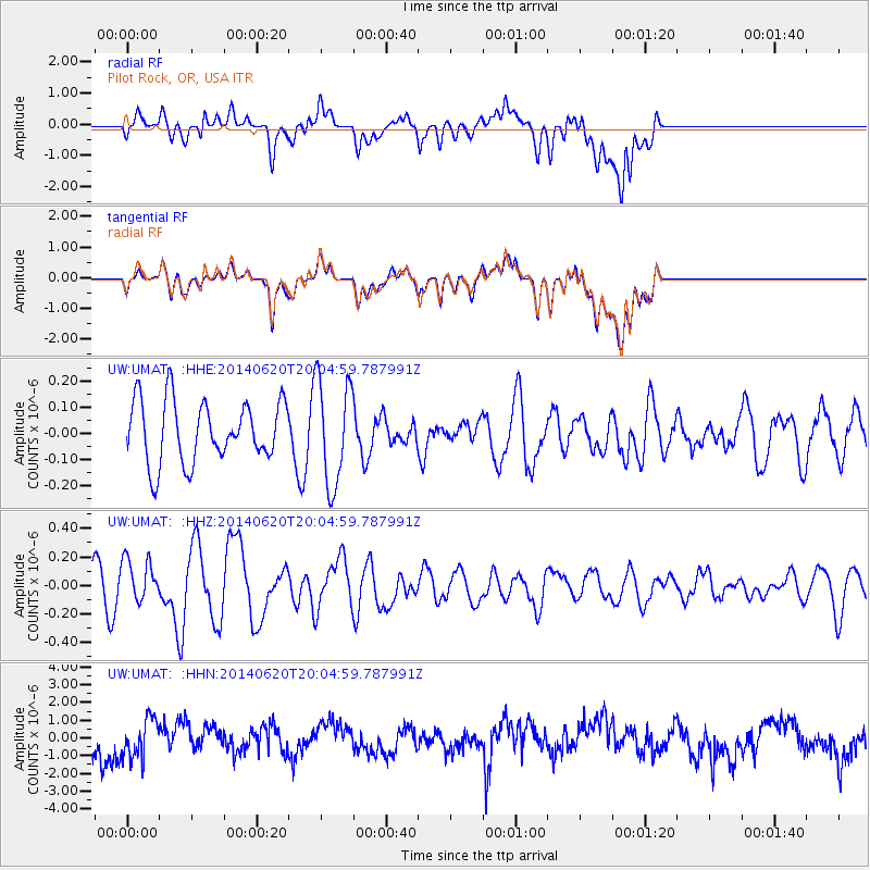
UMAT Pilot Rock, OR, USA - Earthquake Result Viewer
*The percent match for this event was below the threshold and hence no stack was calculated.
| Earthquake location: |
Near Coast Of Northern Chile |
| Earthquake latitude/longitude: |
-19.8/-70.9 |
| Earthquake time(UTC): |
2014/06/20 (171) 19:53:32 GMT |
| Earthquake Depth: |
14 km |
| Earthquake Magnitude: |
5.5 MB |
| Earthquake Catalog/Contributor: |
NEIC PDE/NEIC COMCAT |
|
| Network: |
UW Pacific Northwest Regional Seismic Network |
| Station: |
UMAT Pilot Rock, OR, USA |
| Lat/Lon: |
45.29 N/118.96 W |
| Elevation: |
1318 m |
|
| Distance: |
78.2 deg |
| Az: |
327.535 deg |
| Baz: |
134.279 deg |
| Ray Param: |
$rayparam |
*The percent match for this event was below the threshold and hence was not used in the summary stack. |
|
| Radial Match: |
47.82472 % |
| Radial Bump: |
400 |
| Transverse Match: |
47.11466 % |
| Transverse Bump: |
400 |
| SOD ConfigId: |
739768 |
| Insert Time: |
2014-07-04 20:49:09.831 +0000 |
| GWidth: |
2.5 |
| Max Bumps: |
400 |
| Tol: |
0.001 |
|
Signal To Noise
| Channel | StoN | STA | LTA |
| UW:UMAT: :HHZ:20140620T20:04:59.787991Z | 1.207755 | 1.5273943E-7 | 1.2646558E-7 |
| UW:UMAT: :HHN:20140620T20:04:59.787991Z | 1.6166987 | 1.0920174E-6 | 6.754613E-7 |
| UW:UMAT: :HHE:20140620T20:04:59.787991Z | 1.7283201 | 2.0158848E-7 | 1.1663838E-7 |
| Arrivals |
| Ps | |
| PpPs | |
| PsPs/PpSs | |


