You are here: Home > Network List > KZ - Kazakhstan Network Stations List
> Station MAKZ Makanchi, Kazakstan > Earthquake Result Viewer
MAKZ Makanchi, Kazakstan - Earthquake Result Viewer
| Earthquake location: |
Northern Molucca Sea |
| Earthquake latitude/longitude: |
1.7/126.5 |
| Earthquake time(UTC): |
2015/03/17 (076) 22:12:28 GMT |
| Earthquake Depth: |
42 km |
| Earthquake Magnitude: |
6.6 MO |
| Earthquake Catalog/Contributor: |
NEIC PDE/NEIC ALERT |
|
| Network: |
KZ Kazakhstan Network |
| Station: |
MAKZ Makanchi, Kazakstan |
| Lat/Lon: |
46.81 N/81.98 E |
| Elevation: |
600 m |
|
| Distance: |
59.3 deg |
| Az: |
325.927 deg |
| Baz: |
125.383 deg |
| Ray Param: |
0.062179066 |
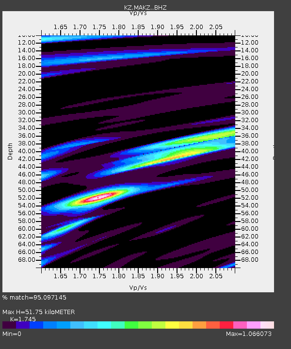
| Estimated Moho Depth: |
51.75 km |
| Estimated Crust Vp/Vs: |
1.75 |
| Assumed Crust Vp: |
6.571 km/s |
| Estimated Crust Vs: |
3.765 km/s |
| Estimated Crust Poisson's Ratio: |
0.26 |
|
| Radial Match: |
95.097145 % |
| Radial Bump: |
371 |
| Transverse Match: |
88.955 % |
| Transverse Bump: |
400 |
| SOD ConfigId: |
7422571 |
| Insert Time: |
2019-04-17 19:48:16.322 +0000 |
| GWidth: |
2.5 |
| Max Bumps: |
400 |
| Tol: |
0.001 |
|

Signal To Noise
| Channel | StoN | STA | LTA |
| KZ:MAKZ: :BHZ:20150317T22:21:55.349988Z | 18.903072 | 1.44122E-6 | 7.6242635E-8 |
| KZ:MAKZ: :BHN:20150317T22:21:55.349988Z | 14.004389 | 4.2764285E-7 | 3.0536345E-8 |
| KZ:MAKZ: :BHE:20150317T22:21:55.349988Z | 11.37437 | 5.5559985E-7 | 4.8846648E-8 |
| Arrivals |
| Ps | 6.2 SECOND |
| PpPs | 21 SECOND |
| PsPs/PpSs | 27 SECOND |


