You are here: Home > Network List > PF - Volcanologic Network of Piton de Fournaise-OVPF Stations List
> Station GPS Grandes Pentes Sud > Earthquake Result Viewer
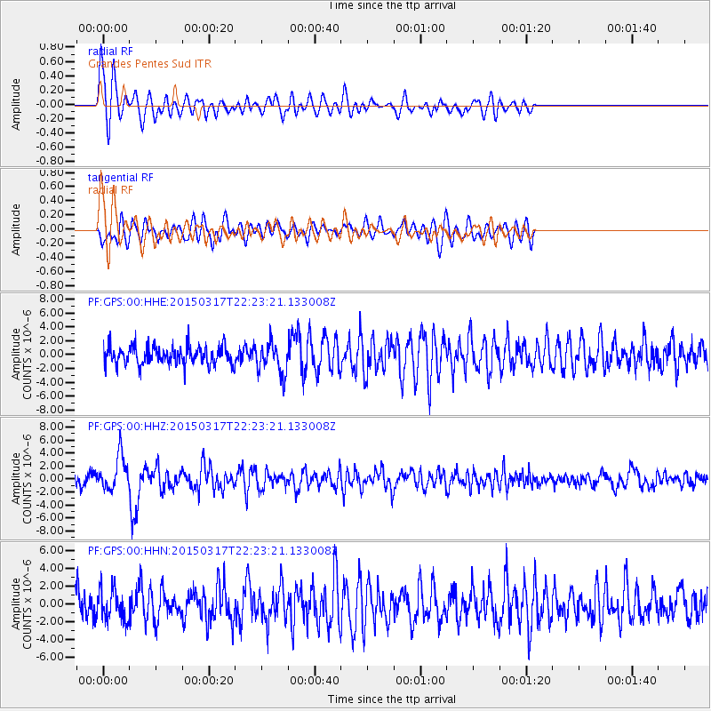
GPS Grandes Pentes Sud - Earthquake Result Viewer
*The percent match for this event was below the threshold and hence no stack was calculated.
| Earthquake location: |
Northern Molucca Sea |
| Earthquake latitude/longitude: |
1.7/126.5 |
| Earthquake time(UTC): |
2015/03/17 (076) 22:12:28 GMT |
| Earthquake Depth: |
42 km |
| Earthquake Magnitude: |
6.6 MO |
| Earthquake Catalog/Contributor: |
NEIC PDE/NEIC ALERT |
|
| Network: |
PF Volcanologic Network of Piton de Fournaise-OVPF |
| Station: |
GPS Grandes Pentes Sud |
| Lat/Lon: |
21.27 S/55.76 E |
| Elevation: |
1004 m |
|
| Distance: |
72.7 deg |
| Az: |
247.249 deg |
| Baz: |
81.231 deg |
| Ray Param: |
$rayparam |
*The percent match for this event was below the threshold and hence was not used in the summary stack. |
|
| Radial Match: |
72.17155 % |
| Radial Bump: |
400 |
| Transverse Match: |
60.72104 % |
| Transverse Bump: |
400 |
| SOD ConfigId: |
7422571 |
| Insert Time: |
2019-04-17 19:48:30.472 +0000 |
| GWidth: |
2.5 |
| Max Bumps: |
400 |
| Tol: |
0.001 |
|
Signal To Noise
| Channel | StoN | STA | LTA |
| PF:GPS:00:HHZ:20150317T22:23:21.133008Z | 2.9288216 | 2.6411915E-6 | 9.0179327E-7 |
| PF:GPS:00:HHN:20150317T22:23:21.133008Z | 1.2436188 | 1.7648147E-6 | 1.4190961E-6 |
| PF:GPS:00:HHE:20150317T22:23:21.133008Z | 1.6984177 | 2.2281079E-6 | 1.3118727E-6 |
| Arrivals |
| Ps | |
| PpPs | |
| PsPs/PpSs | |


