You are here: Home > Network List > TA - USArray Transportable Network (new EarthScope stations) Stations List
> Station A21K Barrow, AK, USA > Earthquake Result Viewer
A21K Barrow, AK, USA - Earthquake Result Viewer
| Earthquake location: |
Northern Molucca Sea |
| Earthquake latitude/longitude: |
1.7/126.5 |
| Earthquake time(UTC): |
2015/03/17 (076) 22:12:28 GMT |
| Earthquake Depth: |
42 km |
| Earthquake Magnitude: |
6.6 MO |
| Earthquake Catalog/Contributor: |
NEIC PDE/NEIC ALERT |
|
| Network: |
TA USArray Transportable Network (new EarthScope stations) |
| Station: |
A21K Barrow, AK, USA |
| Lat/Lon: |
71.32 N/156.62 W |
| Elevation: |
577 m |
|
| Distance: |
84.2 deg |
| Az: |
18.381 deg |
| Baz: |
258.058 deg |
| Ray Param: |
0.045562495 |
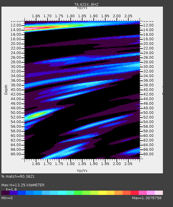
| Estimated Moho Depth: |
13.25 km |
| Estimated Crust Vp/Vs: |
1.60 |
| Assumed Crust Vp: |
6.048 km/s |
| Estimated Crust Vs: |
3.78 km/s |
| Estimated Crust Poisson's Ratio: |
0.18 |
|
| Radial Match: |
90.3621 % |
| Radial Bump: |
380 |
| Transverse Match: |
88.76471 % |
| Transverse Bump: |
400 |
| SOD ConfigId: |
7422571 |
| Insert Time: |
2019-04-17 19:48:53.236 +0000 |
| GWidth: |
2.5 |
| Max Bumps: |
400 |
| Tol: |
0.001 |
|
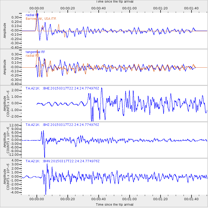
Signal To Noise
| Channel | StoN | STA | LTA |
| TA:A21K: :BHZ:20150317T22:24:24.774976Z | 27.141663 | 2.855604E-6 | 1.0521109E-7 |
| TA:A21K: :BHN:20150317T22:24:24.774976Z | 3.3919199 | 6.164413E-7 | 1.8173817E-7 |
| TA:A21K: :BHE:20150317T22:24:24.774976Z | 4.757542 | 6.806452E-7 | 1.4306656E-7 |
| Arrivals |
| Ps | 1.3 SECOND |
| PpPs | 5.6 SECOND |
| PsPs/PpSs | 6.9 SECOND |


