You are here: Home > Network List > OK - Oklahoma Seismic Network Stations List
> Station X37A Clayton, OK, USA > Earthquake Result Viewer
X37A Clayton, OK, USA - Earthquake Result Viewer
| Earthquake location: |
Near Coast Of Northern Chile |
| Earthquake latitude/longitude: |
-19.8/-70.9 |
| Earthquake time(UTC): |
2014/06/20 (171) 20:22:28 GMT |
| Earthquake Depth: |
16 km |
| Earthquake Magnitude: |
5.6 MB |
| Earthquake Catalog/Contributor: |
NEIC PDE/NEIC COMCAT |
|
| Network: |
OK Oklahoma Seismic Network |
| Station: |
X37A Clayton, OK, USA |
| Lat/Lon: |
34.59 N/95.37 W |
| Elevation: |
207 m |
|
| Distance: |
58.9 deg |
| Az: |
336.489 deg |
| Baz: |
152.92 deg |
| Ray Param: |
0.06252935 |
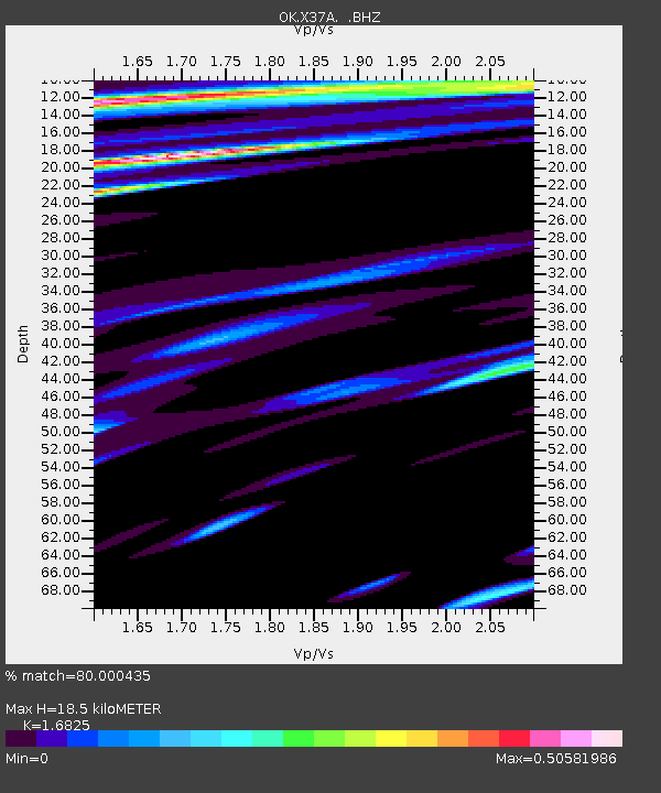
| Estimated Moho Depth: |
18.5 km |
| Estimated Crust Vp/Vs: |
1.68 |
| Assumed Crust Vp: |
6.498 km/s |
| Estimated Crust Vs: |
3.862 km/s |
| Estimated Crust Poisson's Ratio: |
0.23 |
|
| Radial Match: |
80.000435 % |
| Radial Bump: |
400 |
| Transverse Match: |
66.18447 % |
| Transverse Bump: |
400 |
| SOD ConfigId: |
739768 |
| Insert Time: |
2014-07-04 21:08:15.134 +0000 |
| GWidth: |
2.5 |
| Max Bumps: |
400 |
| Tol: |
0.001 |
|

Signal To Noise
| Channel | StoN | STA | LTA |
| OK:X37A: :BHZ:20140620T20:31:55.675027Z | 2.685443 | 1.9696479E-7 | 7.334537E-8 |
| OK:X37A: :BHN:20140620T20:31:55.675027Z | 1.2564336 | 8.446947E-8 | 6.722955E-8 |
| OK:X37A: :BHE:20140620T20:31:55.675027Z | 1.9866639 | 1.6447414E-7 | 8.278911E-8 |
| Arrivals |
| Ps | 2.0 SECOND |
| PpPs | 7.3 SECOND |
| PsPs/PpSs | 9.3 SECOND |


