You are here: Home > Network List > TA - USArray Transportable Network (new EarthScope stations) Stations List
> Station M60A Port Jervis, NY, USA > Earthquake Result Viewer
M60A Port Jervis, NY, USA - Earthquake Result Viewer
| Earthquake location: |
Near Coast Of Northern Chile |
| Earthquake latitude/longitude: |
-19.8/-70.9 |
| Earthquake time(UTC): |
2014/06/20 (171) 20:22:28 GMT |
| Earthquake Depth: |
16 km |
| Earthquake Magnitude: |
5.6 MB |
| Earthquake Catalog/Contributor: |
NEIC PDE/NEIC COMCAT |
|
| Network: |
TA USArray Transportable Network (new EarthScope stations) |
| Station: |
M60A Port Jervis, NY, USA |
| Lat/Lon: |
41.33 N/74.62 W |
| Elevation: |
292 m |
|
| Distance: |
60.9 deg |
| Az: |
356.802 deg |
| Baz: |
176.001 deg |
| Ray Param: |
0.06119114 |
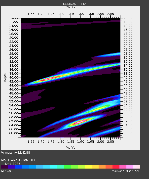
| Estimated Moho Depth: |
62.0 km |
| Estimated Crust Vp/Vs: |
1.90 |
| Assumed Crust Vp: |
6.283 km/s |
| Estimated Crust Vs: |
3.311 km/s |
| Estimated Crust Poisson's Ratio: |
0.31 |
|
| Radial Match: |
82.4188 % |
| Radial Bump: |
400 |
| Transverse Match: |
72.572044 % |
| Transverse Bump: |
400 |
| SOD ConfigId: |
739768 |
| Insert Time: |
2014-07-04 21:16:17.416 +0000 |
| GWidth: |
2.5 |
| Max Bumps: |
400 |
| Tol: |
0.001 |
|

Signal To Noise
| Channel | StoN | STA | LTA |
| TA:M60A: :BHZ:20140620T20:32:09.624978Z | 1.96098 | 3.86099E-7 | 1.9689084E-7 |
| TA:M60A: :BHN:20140620T20:32:09.624978Z | 1.0779146 | 1.5629078E-7 | 1.4499365E-7 |
| TA:M60A: :BHE:20140620T20:32:09.624978Z | 1.2229458 | 8.034023E-8 | 6.569402E-8 |
| Arrivals |
| Ps | 9.2 SECOND |
| PpPs | 27 SECOND |
| PsPs/PpSs | 37 SECOND |


