You are here: Home > Network List > US - United States National Seismic Network Stations List
> Station MNTX Cornudas Mountains, Texas, USA > Earthquake Result Viewer
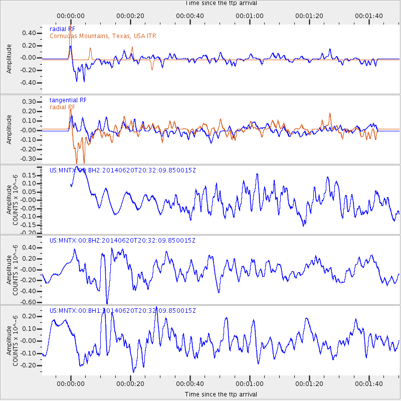
MNTX Cornudas Mountains, Texas, USA - Earthquake Result Viewer
*The percent match for this event was below the threshold and hence no stack was calculated.
| Earthquake location: |
Near Coast Of Northern Chile |
| Earthquake latitude/longitude: |
-19.8/-70.9 |
| Earthquake time(UTC): |
2014/06/20 (171) 20:22:28 GMT |
| Earthquake Depth: |
16 km |
| Earthquake Magnitude: |
5.6 MB |
| Earthquake Catalog/Contributor: |
NEIC PDE/NEIC COMCAT |
|
| Network: |
US United States National Seismic Network |
| Station: |
MNTX Cornudas Mountains, Texas, USA |
| Lat/Lon: |
31.70 N/105.38 W |
| Elevation: |
404 m |
|
| Distance: |
61.0 deg |
| Az: |
326.511 deg |
| Baz: |
142.451 deg |
| Ray Param: |
$rayparam |
*The percent match for this event was below the threshold and hence was not used in the summary stack. |
|
| Radial Match: |
80.014786 % |
| Radial Bump: |
400 |
| Transverse Match: |
60.62433 % |
| Transverse Bump: |
400 |
| SOD ConfigId: |
739768 |
| Insert Time: |
2014-07-04 21:21:49.776 +0000 |
| GWidth: |
2.5 |
| Max Bumps: |
400 |
| Tol: |
0.001 |
|
Signal To Noise
| Channel | StoN | STA | LTA |
| US:MNTX:00:BHZ:20140620T20:32:09.850015Z | 1.2806325 | 1.8983016E-7 | 1.4823156E-7 |
| US:MNTX:00:BH1:20140620T20:32:09.850015Z | 0.9483064 | 1.1773955E-7 | 1.2415772E-7 |
| US:MNTX:00:BH2:20140620T20:32:09.850015Z | 0.92534083 | 7.625418E-8 | 8.240659E-8 |
| Arrivals |
| Ps | |
| PpPs | |
| PsPs/PpSs | |


