You are here: Home > Network List > II - Global Seismograph Network (GSN - IRIS/IDA) Stations List
> Station WRAB Tennant Creek, NT, Australia > Earthquake Result Viewer
WRAB Tennant Creek, NT, Australia - Earthquake Result Viewer
| Earthquake location: |
Xizang |
| Earthquake latitude/longitude: |
35.1/87.3 |
| Earthquake time(UTC): |
1997/11/08 (312) 10:02:52 GMT |
| Earthquake Depth: |
33 km |
| Earthquake Magnitude: |
6.2 MB, 7.9 MS, 7.7 UNKNOWN, 7.6 MW |
| Earthquake Catalog/Contributor: |
WHDF/NEIC |
|
| Network: |
II Global Seismograph Network (GSN - IRIS/IDA) |
| Station: |
WRAB Tennant Creek, NT, Australia |
| Lat/Lon: |
19.93 S/134.36 E |
| Elevation: |
366 m |
|
| Distance: |
70.6 deg |
| Az: |
133.123 deg |
| Baz: |
320.478 deg |
| Ray Param: |
0.054823995 |
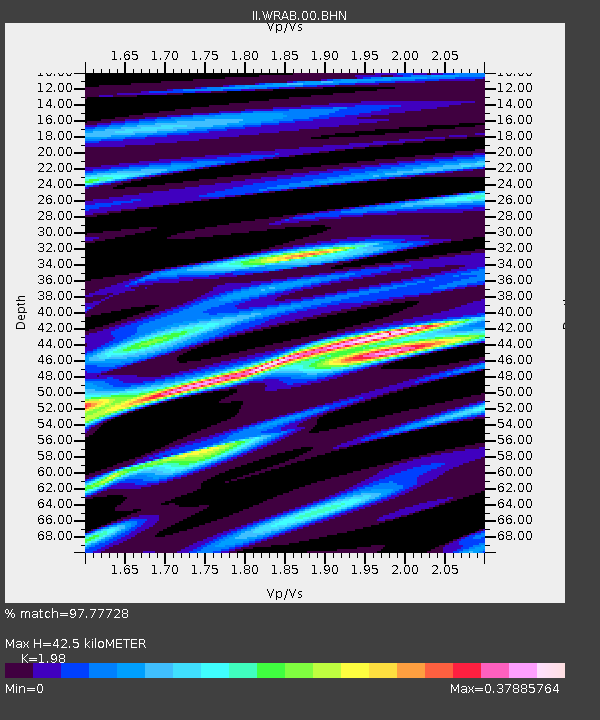
| Estimated Moho Depth: |
42.5 km |
| Estimated Crust Vp/Vs: |
1.98 |
| Assumed Crust Vp: |
6.642 km/s |
| Estimated Crust Vs: |
3.355 km/s |
| Estimated Crust Poisson's Ratio: |
0.33 |
|
| Radial Match: |
97.77728 % |
| Radial Bump: |
238 |
| Transverse Match: |
90.57557 % |
| Transverse Bump: |
400 |
| SOD ConfigId: |
6273 |
| Insert Time: |
2010-03-01 23:18:31.196 +0000 |
| GWidth: |
2.5 |
| Max Bumps: |
400 |
| Tol: |
0.001 |
|
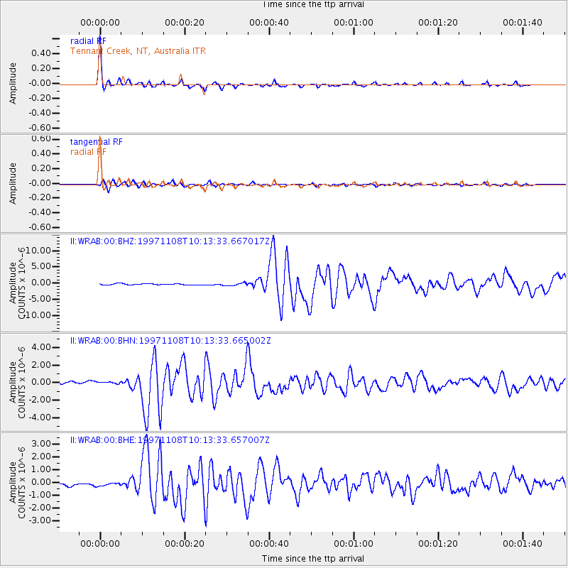
Signal To Noise
| Channel | StoN | STA | LTA |
| II:WRAB:00:BHN:19971108T10:13:33.665002Z | 0.60270315 | 1.03038545E-7 | 1.7096069E-7 |
| II:WRAB:00:BHE:19971108T10:13:33.657007Z | 1.2086095 | 1.1698088E-7 | 9.678965E-8 |
| II:WRAB:00:BHZ:19971108T10:13:33.667017Z | 2.2121198 | 4.266513E-7 | 1.9286989E-7 |
| Arrivals |
| Ps | 6.5 SECOND |
| PpPs | 18 SECOND |
| PsPs/PpSs | 25 SECOND |


