You are here: Home > Network List > CN - Canadian National Seismograph Network Stations List
> Station INK INUVIK, NT > Earthquake Result Viewer
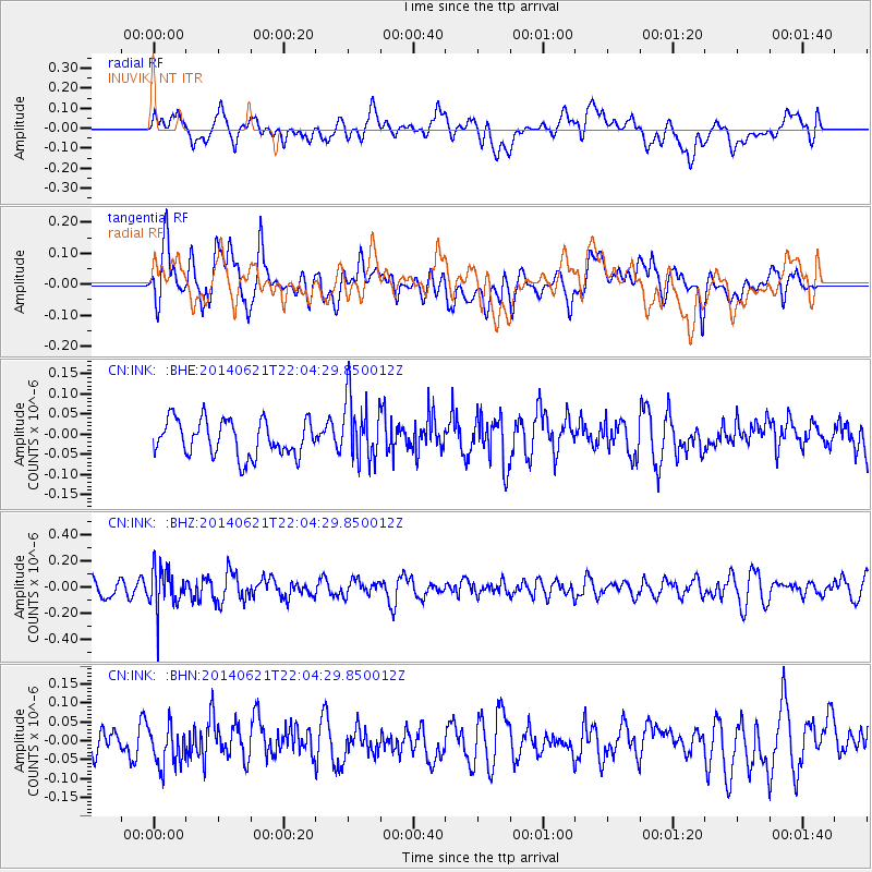
INK INUVIK, NT - Earthquake Result Viewer
*The percent match for this event was below the threshold and hence no stack was calculated.
| Earthquake location: |
Minahassa Peninsula, Sulawesi |
| Earthquake latitude/longitude: |
-0.1/123.0 |
| Earthquake time(UTC): |
2014/06/21 (172) 21:51:51 GMT |
| Earthquake Depth: |
115 km |
| Earthquake Magnitude: |
5.5 MB |
| Earthquake Catalog/Contributor: |
NEIC PDE/NEIC COMCAT |
|
| Network: |
CN Canadian National Seismograph Network |
| Station: |
INK INUVIK, NT |
| Lat/Lon: |
68.31 N/133.53 W |
| Elevation: |
44 m |
|
| Distance: |
95.1 deg |
| Az: |
21.284 deg |
| Baz: |
282.487 deg |
| Ray Param: |
$rayparam |
*The percent match for this event was below the threshold and hence was not used in the summary stack. |
|
| Radial Match: |
43.49758 % |
| Radial Bump: |
400 |
| Transverse Match: |
54.1358 % |
| Transverse Bump: |
400 |
| SOD ConfigId: |
739768 |
| Insert Time: |
2014-07-05 22:01:47.913 +0000 |
| GWidth: |
2.5 |
| Max Bumps: |
400 |
| Tol: |
0.001 |
|
Signal To Noise
| Channel | StoN | STA | LTA |
| CN:INK: :BHZ:20140621T22:04:29.850012Z | 2.7445655 | 1.6017292E-7 | 5.836003E-8 |
| CN:INK: :BHN:20140621T22:04:29.850012Z | 1.1086198 | 5.097076E-8 | 4.5976773E-8 |
| CN:INK: :BHE:20140621T22:04:29.850012Z | 1.7732797 | 7.919263E-8 | 4.465885E-8 |
| Arrivals |
| Ps | |
| PpPs | |
| PsPs/PpSs | |


