You are here: Home > Network List > AK - Alaska Regional Network Stations List
> Station CHN Chernabura Island, AK, USA > Earthquake Result Viewer
CHN Chernabura Island, AK, USA - Earthquake Result Viewer
| Earthquake location: |
Kermadec Islands, New Zealand |
| Earthquake latitude/longitude: |
-30.1/-177.7 |
| Earthquake time(UTC): |
2014/06/23 (174) 19:19:16 GMT |
| Earthquake Depth: |
20 km |
| Earthquake Magnitude: |
6.9 MWW, 6.7 MWB, 7.2 MI |
| Earthquake Catalog/Contributor: |
NEIC PDE/NEIC COMCAT |
|
| Network: |
AK Alaska Regional Network |
| Station: |
CHN Chernabura Island, AK, USA |
| Lat/Lon: |
54.83 N/159.59 W |
| Elevation: |
71 m |
|
| Distance: |
86.0 deg |
| Az: |
10.37 deg |
| Baz: |
195.638 deg |
| Ray Param: |
0.044328675 |
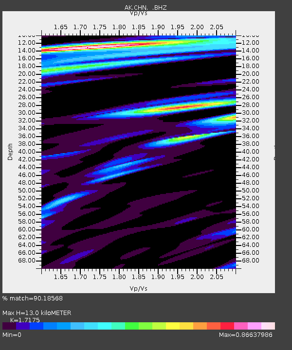
| Estimated Moho Depth: |
13.0 km |
| Estimated Crust Vp/Vs: |
1.72 |
| Assumed Crust Vp: |
5.989 km/s |
| Estimated Crust Vs: |
3.487 km/s |
| Estimated Crust Poisson's Ratio: |
0.24 |
|
| Radial Match: |
90.18568 % |
| Radial Bump: |
400 |
| Transverse Match: |
88.2826 % |
| Transverse Bump: |
400 |
| SOD ConfigId: |
739768 |
| Insert Time: |
2014-07-07 19:41:48.554 +0000 |
| GWidth: |
2.5 |
| Max Bumps: |
400 |
| Tol: |
0.001 |
|

Signal To Noise
| Channel | StoN | STA | LTA |
| AK:CHN: :BHZ:20140623T19:31:24.008025Z | 9.62843 | 1.8331019E-6 | 1.903843E-7 |
| AK:CHN: :BHN:20140623T19:31:24.008025Z | 4.119515 | 5.4790104E-7 | 1.3300135E-7 |
| AK:CHN: :BHE:20140623T19:31:24.008025Z | 2.121111 | 3.2066472E-7 | 1.5117773E-7 |
| Arrivals |
| Ps | 1.6 SECOND |
| PpPs | 5.8 SECOND |
| PsPs/PpSs | 7.4 SECOND |


