You are here: Home > Network List > TA - USArray Transportable Network (new EarthScope stations) Stations List
> Station H63A New Sharon, ME, USA > Earthquake Result Viewer
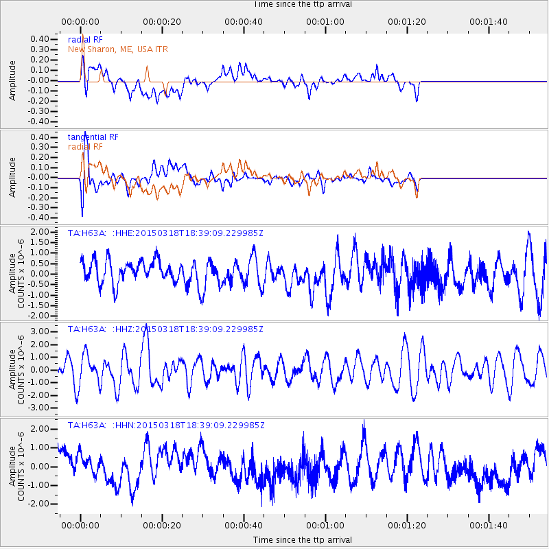
H63A New Sharon, ME, USA - Earthquake Result Viewer
*The percent match for this event was below the threshold and hence no stack was calculated.
| Earthquake location: |
Near Coast Of Central Chile |
| Earthquake latitude/longitude: |
-36.1/-73.6 |
| Earthquake time(UTC): |
2015/03/18 (077) 18:27:28 GMT |
| Earthquake Depth: |
10 km |
| Earthquake Magnitude: |
6.2 MWB, 6.2 MWW |
| Earthquake Catalog/Contributor: |
NEIC PDE/NEIC COMCAT |
|
| Network: |
TA USArray Transportable Network (new EarthScope stations) |
| Station: |
H63A New Sharon, ME, USA |
| Lat/Lon: |
44.66 N/70.04 W |
| Elevation: |
109 m |
|
| Distance: |
80.4 deg |
| Az: |
2.598 deg |
| Baz: |
182.948 deg |
| Ray Param: |
$rayparam |
*The percent match for this event was below the threshold and hence was not used in the summary stack. |
|
| Radial Match: |
29.199406 % |
| Radial Bump: |
400 |
| Transverse Match: |
74.34006 % |
| Transverse Bump: |
400 |
| SOD ConfigId: |
7422571 |
| Insert Time: |
2019-04-17 19:56:22.900 +0000 |
| GWidth: |
2.5 |
| Max Bumps: |
400 |
| Tol: |
0.001 |
|
Signal To Noise
| Channel | StoN | STA | LTA |
| TA:H63A: :HHZ:20150318T18:39:09.229985Z | 1.5207753 | 1.2538338E-6 | 8.2447013E-7 |
| TA:H63A: :HHN:20150318T18:39:09.229985Z | 0.8076891 | 7.9633895E-7 | 9.859475E-7 |
| TA:H63A: :HHE:20150318T18:39:09.229985Z | 1.5179249 | 7.756536E-7 | 5.10996E-7 |
| Arrivals |
| Ps | |
| PpPs | |
| PsPs/PpSs | |


