You are here: Home > Network List > AU - Australian Seismological Centre Stations List
> Station RABL Rabaul, Papau New Guinea > Earthquake Result Viewer
RABL Rabaul, Papau New Guinea - Earthquake Result Viewer
| Earthquake location: |
Kermadec Islands, New Zealand |
| Earthquake latitude/longitude: |
-30.1/-177.7 |
| Earthquake time(UTC): |
2014/06/23 (174) 19:19:16 GMT |
| Earthquake Depth: |
20 km |
| Earthquake Magnitude: |
6.9 MWW, 6.7 MWB, 7.2 MI |
| Earthquake Catalog/Contributor: |
NEIC PDE/NEIC COMCAT |
|
| Network: |
AU Australian Seismological Centre |
| Station: |
RABL Rabaul, Papau New Guinea |
| Lat/Lon: |
4.19 S/152.16 E |
| Elevation: |
277 m |
|
| Distance: |
38.4 deg |
| Az: |
306.259 deg |
| Baz: |
135.532 deg |
| Ray Param: |
0.075541414 |
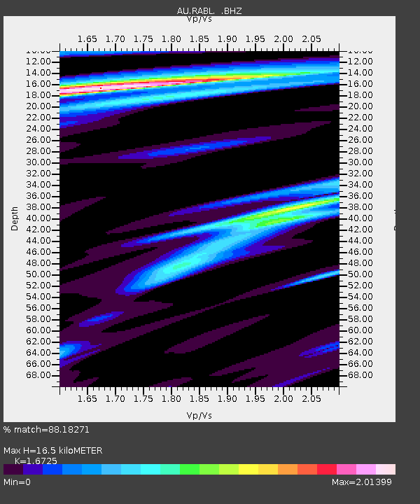
| Estimated Moho Depth: |
16.5 km |
| Estimated Crust Vp/Vs: |
1.67 |
| Assumed Crust Vp: |
6.183 km/s |
| Estimated Crust Vs: |
3.697 km/s |
| Estimated Crust Poisson's Ratio: |
0.22 |
|
| Radial Match: |
88.18271 % |
| Radial Bump: |
366 |
| Transverse Match: |
82.366135 % |
| Transverse Bump: |
400 |
| SOD ConfigId: |
739768 |
| Insert Time: |
2014-07-07 19:47:48.188 +0000 |
| GWidth: |
2.5 |
| Max Bumps: |
400 |
| Tol: |
0.001 |
|

Signal To Noise
| Channel | StoN | STA | LTA |
| AU:RABL: :BHZ:20140623T19:26:05.919005Z | 22.25082 | 2.3082082E-6 | 1.0373587E-7 |
| AU:RABL: :BHN:20140623T19:26:05.919005Z | 3.9325762 | 1.2354866E-6 | 3.1416727E-7 |
| AU:RABL: :BHE:20140623T19:26:05.919005Z | 4.8386674 | 1.2561942E-6 | 2.5961572E-7 |
| Arrivals |
| Ps | 1.9 SECOND |
| PpPs | 6.6 SECOND |
| PsPs/PpSs | 8.6 SECOND |


